If you’re looking to visit the Isles Of Scotland but have no idea which of the 700 islands would be best for you, we have found some of the best Scottish Islands for you to visit whatever the season. From the Orkney Islands to the tiny, pedestrianised island of Iona, we will find the best island in Scotland for you. Here we list 60 Isles of Scotland (and the list growing) that we think are great for hopping, exploring, relaxing on and even swimming!
How Many Isles of Scotland Are There?
Scotland has 790 islands, which I’m sure will surprise you, and furthermore, Scotland has more than 10% of Europe’s entire coastline. It is three-quarters surrounded by sea after all. Only 130 islands have permanent inhabitants and some form of transport to get you there – although others are accessible on day trips.
The islands of Scotland are divided into five categories; The Outer Hebrides, The Inner Hebrides, the Shetland Islands, Orkney Island, the Firth of Forth and the tidal islands.
The Inner Hebrides is made up of 35 inhabited islands as well as 44 uninhabited islands that stretch along Scotland’s western coast. The three largest islands with the highest populations are Skye, Mull, and Islay. The Inner Hebrides are best reached from Glasgow, via car, ferry or by air depending on which island you are visiting.
Also known as The Western Isles, or Na h-Eileanan an Iar in Gaelic, the Outer Hebrides consist of 15 inhabited islands with a total population of 26,830 and more than 50 uninhabited islands. The beaches of the Outer Hebrides are often confused with beaches of the Caribbean, with their powder-white sand and crystal-clear waters. The Isle of Lewis and Harris, Barra and South Uist are three of the main islands of the Outer Hebrides.
With UNESCO World Heritage Sites, white sandy beaches, and amazing wildlife, the Orkney Islands make an extremely popular holiday destination. There are about 70 Orkney Islands, 20 of which are inhabited. Many travellers like to visit the Orkney Islands during the Autumn and Winter months for a greater chance of spotting the Northern Lights. Some of Orkney’s largest or most popular islands include Kirkwall, Hoy and Eday.
The Shetland Islands are located 130 miles north of the Scottish mainland and 190 miles west of Norway, making it the UK’s most northerly point. Around 100 islands fall under Shetland, with fewer than 20 of them inhabited. The three most populated islands of Shetland are Lerwick, the capital of the islands, Yell and Scalloway.

Map Of The Scottish Islands Listed Below
You can use this map from Google to locate all of the Isles of Scotland.
How Can You Get Around The Scottish Isles?
Although there are some airports, it isn’t a true adventure until you’ve hopped on a ferry and braved those Atlantic or Northern Seas – and in winter they can be rough!
Some of the ferries accommodate cars and camper vans although some, like the ferries to Iona and Muck, Eigg & Rum are passenger only. Some islands you’ll only be able to visit at low tide or by hiring a local fisherman and boat to take you.
I’ve never had a bad experience on a Scottish island and most locals are welcoming and friendly but please remember to leave no trace.
Enlarge

Which Island Should I Visit In Scotland?
The Isle of Skye, in the Inner Hebrides, is the most visited of all the islands in Scotland and whilst the Outer Hebrides are mostly moorland, peat bogs and lochs (with the exception of mountainous Harris) they have some of the most beautiful white-sand beaches you’ll likely ever see in the UK!
The Shetland Islands are the furthest away from the Scottish mainland and Fair Isle is an isolated island found between The Shetland and The Orkney Islands. North Rona is closer to the Faroe Islands than Scotland and the Slate Islands have a unique feel to them due to their slate mining history.
Stornoway on Lewis, Kirkwall in Orkney and Lerwick in Shetland are the Scottish islands’ largest towns. All three are the hub of activity on their respective islands but if you’re looking for a total get-away experience there are still some private islands that only have two inhabitants living on them.
The best islands for scuba-diving are Scapa Flow in the Orkney Islands, St Kilda & Mull where water temperatures range from 4°C in April to 14°C in September. Wild camping in a tent is allowed all over Scotland on condition that you remember the Scottish Outdoor Access Code.
Whether you’re looking for adrenaline-filled adventures, beach holidays, long hikes or total relaxation and whisky tastings, we’ve listed 54 islands below so you can find your perfect Isle of Scotland holiday.
Isles Of Scotland: Best Scottish Islands To Visit
Arran
The island of Arran is one of the most accessible Scottish islands and you can drive to Arran from Glasgow in just a couple of hours. Despite being so close to the mainland, Arran has a relaxed atmosphere coupled with dramatic scenery and eclectic wildlife of the Inner Hebrides.
The ferry route to Arran goes via the town of Ardrossdan on Scotland’s south-west coast. It takes around an hour to drive to the port from Glasgow, or you can also get the train to Ardrossan station which is right by the port. If you are only planning on visiting the island for a couple of days, I would recommend taking your car over. Some of the main attractions are at opposite ends of the island so having your own vehicle means no waiting about for public transport.
What’s so special about the Isle of Arran is that it feels like a microcosm of Scotland all rolled into a tiny island. Stunning mountain glens, charming seaside towns and a rich history. If you’re short on time, it’s easy enough to see most of the top spots in a couple of days however, this gorgeous island is also the perfect destination for a longer, more laid-back island break in Scotland.
Much of the tourist accommodation is located around Brodick, the main settlement since there’s a lot to do within a short distance. If you’re planning to use public transport while you’re on Arran, there are plenty of public bus routes that leave from Brodick and take you right around the island. During the peak tourist season (roughly May-September), it’s also possible to secure a place on an organised tour group.
The island of Arran has plenty of hiking trails with a range of difficulties. The most challenging, but also the most rewarding, is the hike up to Goatfell. This pyramidal peak is the highest point on Arran, and a tough 5-hour climb will reward you with incredible views over the island. If you’re looking for some more gentle options, opt for the hiking trail to Glenashdale Falls and the Giant’s Graves. This circular walk is much easier but still gives you the chance to see some of Arran’s most beautiful scenery.
A large amount of produce is made on the island; from gin and whisky to ice cream and cheese, there are so many Isle of Arran products to try. Brodrick is a great spot to shop for all things Arran. If you want some souvenirs, visit Arran Aromatics to pick up some incredible home gifts inspired by the island.
Arran is a true Scottish Island gem that you’ll definitely not want to miss.
Written by Emma from The Hobby Traveller. See more from Emma on Instagram.
Book Your Stay On Arran
Scroll out to view more properties.
<
Things To Do On Arran
Barra
Barra is the most southerly occupied island in the Outer Hebrides archipelago and the most westerly island in the UK. It is truly special amongst Scotland’s glorious islands and a perfect place to visit when road tripping the beautiful UK.
You can get to Barra by car ferry from Oban to Castlebay, which takes around 4-5 hours. For a once in a lifetime experience, fly into Barra’s unique beach airstrip, airport at Cockle Strand in between the tides on Traigh Mor Beach. After landing on the beach, head to the small airport terminal for one of the friendliest welcomes you’ll ever receive and to pick up your hire car.
Although it is only 9 miles long, Barra is known for its stunning white sandy beaches, big skies and wild landscapes, the island of Barra is a place to visit and contemplate life, take long walks and enjoy the wonderful flora and fauna that is all around you. If you love the great outdoors, this is the Scottish island for you. With great hiking routes, roads safe to cycle on, sea kayaking, diving and even a golf course there is plenty to keep visitors occupied.
Barra also has a rich history, from the first settlers in 2500BC and the archaeological sites which tell their story to the fascinating and convoluted history of clan Macneil of Barra and Kisimul Castle, their rocky island stronghold in the waters of Castlebay. For an overview of the island’s past and culture, visit the island’s heritage centre, Dualchas, where you’ll find local history displays and art exhibitions, as well as cultural events.
View the Barra seals at Seal Bay or if you have wetsuits (you’ll need them) head for Halaman Bay for some swimming and even surfing but if you’re looking for a breathtaking challenge of rollercoaster inclines and dips, try cycling to the island of Vateersay which is connected to Barra via a short causeway. You can rent bikes in Castlebay and don’t forget to check out the deserted village of Eoradail.
For a unique experience on a Scottish Island try the Indian night at Kisimul Cafe. Book in advance as it gets busy, as far as we know this is the only Indian food available on the Outer Hebrides! Many of the local bars also have live traditional music at the weekends, enjoy rousing foot-tapping songs and dancing when you attend a Scottish cèilidh (social event).
If you’re looking for an adventurous day trip. Take a boat trip to three uninhabited southern islands with Islands of Adventure. Visit Flannan Isle, the Blue Lagoon on Pabay Island and see dolphins and porpoise on Little Bernera.
Written by Izzy from The Gap Decaders. See more from Izzy on Facebook.
Enlarge

Belnahua (Abandoned)
The Slate Islands are an island group in the Inner Hebrides situated off the Firth of Lorn. The main islands are Seil, Easdale, Luing, Shuna, Torsa and Belnahua.
Once Belnahua island was home to 200 people, a shop and a school but today it is abandoned and all that is left is a row of derelict, slate workers cottages and rusted, abandoned machinery.
Belnahua is known for its deserted slate quarries which were mined since prehistoric times and helped to roof the British Empire with a global industry connecting it to slate markets in England, Canada and even the West Indies.
This island was a place where little grew and food arrived by boat, along with water when the well ran dry. Life here came to an end during the First World War when the island’s men left to fight and women and children relocated to neighbouring islands which are bigger and have better infrastructure.
The centre of the island has been completely quarried out leaving a gaping hole. The depth of the workings can be seen through the very clear water but in order to visit now you’ll need to kayak or book a private boat from a local fisherman on another island.
You may be able to book via the Heritage Centre on Easdale or from Luing.
Benbecula
The small island of Benbecula lies between North and South Uist in the Outer Hebrides and is frequently used as a stepping stone but take time for this little gem and you’ll be rewarded with beautiful nature and peace like no other.
Benbecula is another ancient island with links to Monastical life in the 6th century and the ruins of Columba’s Church can still be found here south of the main town. The island also has an unusual military history. The airfield built during World War II became the control centre for the Hebrides rocket range, established during the Cold War and is now Benbecula Airport. An army base was established in the 1950s and remains one of the main island employers as it is the headquarters for those who service the South Uist missile testing range.
You can tour the ruins of Borve Castle, a ruined 14th-century tower house, visit St Toranan’s ruined Temple to St Columba but the island is best known for its gorgeous beaches and backed sand dunes. The local marine life includes dolphins, seals, sharks and whales and from the Uist islands, you can book whale-watching expeditions. If you’d prefer to stay on land, try spotting owls and eagles on the East Side or head to the wild machair grasses that carpet the west coast in search of the elusive corncrake.
Walking and cycling are both popular pastimes as Benbecula is flat with many tidal bays and unspoilt moorland to explore. It’s one solitary hill, Rueval, is just 407 ft high. The path to the summit goes past the cave where Bonnie Prince Charlie is reputed to have hidden whilst waiting for Flora MacDonald to arrange his escape from the island.
However, if you’re looking for something more adventurous, book Tom from Benbecula Freedive for adventure waterbased activities. Tom offers Adventure Snorkelling, Freediving, Wreck diving, Spearfishing, Mountain Biking, Kayaking, Personal Training and Fitness classes.
Bute
One of the most easily accessible islands, Bute is best known for its varied landscapes and wildlife. Lush, vibrant green, rolling hills of the island’s centre to the craggy, northern heather-covered moorlands and the delightful sandy beaches around the coastline.
The Isle of Bute is just 33 miles from Glasgow by car and there are two ferries. Leaving from Wemyss Bay you’ll arrive into Rothesay on the east with a 35-minute crossing. The ferry from Colintraive terminal takes 5 minutes crossing to Rhubodach in the north.
Bute is possibly most famous though for its art-deco town of Rothesay where there’s a refurbished pavilion with its palm trees and promenade. Attractions include Rothesay Castle, the stately home at nearby Mount Stuart and some of the country’s best Victorian toilets. No joke!
Bute is relatively large and there’s something for everyone. Is anyone interested in history? Visit the Iron Age fort, Rothesay Castle, the remains of the monastery of St Blane, Mount Stuart House and Bute Museum. For those interested in archaeology there are standing stones – most notably the Kingarth Stones.
You could visit the Bute Community Forest for some simple walks or hike around the West Island Way. Alternatively, hike from Kilchattan Bay to Langalbuinoch and watch the sunset from Stravannan beach and see Arran in the distance. Glen More to Ettrick Bay is another great walk and you can end in Port Bannatyne for a wonderful coffee at the Post Office and choose whether to hike onwards on the old Tramway route to Ettrick Bay.
Beaches St Ninian’s Bay or The Straad is a small bay on the west coast with a natural anchorage. The bay is protected by St Ninian’s Point, a spit of land that can become cut off with tides. Scalpsie Bay is also on the west coast of the island. It is a beautiful and secluded bay with reddish coloured sand. Scalpsie was used for military purposes and the timber posts sunken into the sand are the remains of anti-glider defences.
Of course, no Scottish Island would be complete without alcohol! The Spirit of Bute Brewery is the only brewery on the island and the Isle of Bute Gin’s return Distillery are eagerly awaited. It had to move because it became too popular!
ButeFest is also held on the Isle of Bute, being held next to the beautiful beach at Ettrick Bay and the island even has its own Highland Games! Bute Highland Games is held in August every year and showcases some of the finest highland sportspeople and loads of pipe bands!
Fun Fact: Bute is also home to one of the biggest vegan cheesemakers in the UK. Bute Island Sheese is located in Rothesay and they ship their 28 dairy free sheeses globally.
Canna
Eig, Rum, Muck & Canna form the Small Isles archipelago, in the Inner Hebrides and Canna is the westernmost of the islands. It is linked to the neighbouring island of Sanday by a road and sandbanks at low tide. The island is just 4.3 miles long and 1 mile wide and is a car-free island.
You can get to The Small Isles by the CalMac ferry from Mallaig. The ferry does not call at each island every day; an island may have between three to five sailings per week. Journey times to each island from Mallaig will vary as the ferry travels between the different islands. If you’re feeling brave enough you could hire an offshore RIB operating from Elgol on Skye to both Rum and Canna. Advance booking necessary, telephone 01471 866 244. Arisaig Marine runs cruises lasting 2-5 hours ashore Eigg, Muck and Rum. Operating from April until late September and departing Arisaig at 11am. You must pre-book, telephone: 01687 450224. The harbour office at Arisaig also contains a tea room, showers, toilets, shop and a laundrette.
Known as ‘the garden of the Hebrides’, Canna has beautiful green meadows and 248 native, wild flowering plants. White sandy beaches and spectacular scenery are all easily accessible on foot from Canna’s sheltered harbour. With over 20,000 breeding seabirds, 176 different species, on Canna’s cliffs, there are also plenty of opportunities to spot kittiwakes, razorbills, crossbills and puffins. From the island, you may also spot Minke Whales, Dolphins, Porpoise, Basking Sharks, Otters, Shearwaters and more. Fortunate visitors have also seen Killer Whales, Sea and Golden Eagles, although these are less common.
Things to do on Canna include visiting the Canna community shop, the Canna Tearoom, the Old Dairy exhibits everyday objects and old island photographs, visit the three churches, the Presbyterian ‘Rhu Church’, St Columba’s Chapel and Edward’s Chapel and stop by the historical Canna House and its spectacular garden. Find out how John Lorne Campbell came to buy the island, how he strove to record and save Gaelic songs, poetry and stories that had previously only been passed down by word of mouth and how he built up the most important archive of Gaelic in the world.
The current curator of Canna House is Fiona Mackenzie who has recently published the first book of Margaret Fay Shaw’s heritage photography, entitled Eilean. Using images from Thom collections (1881-1938) giving an unfiltered historical view of Canna. A film festival is planned for spring 2021.
Canna is perfect for long walks and hikes along its steep cliffs. Don’t miss the Souterrains and ‘King of Norway’s Grave’ and the Puffin Stacks. If you’re looking for a 10k the island even has its own race. Black Beach and Sanday Beach are beautiful beaches and if you can, canoe the island’s waters and discover the caves.
Colonsay
If you’re looking for a moderately sized island (10 miles long) with a lot of festivals, head to Colonsay. The Isle of Colonsay has more festivals than any other island; the Book Festival in April, the Festival of Spring in May, the Folk Festival in September and the Autumn Food and Drink Festival in October.
This Inner Hebridean island is a two-hour ferry ride from Oban and Colonsay is most famous for its folk music festival, its jaw-dropping, white sand beaches and as a birdwatchers’ paradise.
With a tiny population of 135 people, there’s just one charming hotel on the island although there are plenty of B&Bs and cottages for rent and of course, in true island fashion, there’s a brewery! On a weekly basis, the hotel offers a quiz night on Thursdays, live local music on Friday nights and a kids DVD night on Tuesdays. During the summer months, there is a ceilidh in the village hall on Saturday nights.
Colonsay’s beaches are some of the most picturesque in Europe and you could spend all week just visiting the beaches of Kiloran, Balnahard, Machrins, Cable Bay, Garvard, Oransay and South East corner. Like many places in Scotland, Colonsay is a marine kindergarten for seal pups and there are at least seven distinct habitats around the island.
Traffic is not heavy on Colonsay and bikes can be rented from the hotel (Tel 01951 200316) and from ‘Jen & Matt’ (Tel 07572180552) and there are also plenty of walks to do including the ancient priory on the neighbouring island of Oronsay.
Other things not to miss are the Colonsay House gardens, the micro-brewery (the most remote brewery in Scotland) as well as two gin distilleries; Colonsay gin made by Wild Thyme Spirits located at Kilchattan and Wild Island Gin made by Colonsay Brewery next to the Village hall.
The caves at the north end of Kiloran Bay although the New Cave to the south requires a bit more planning. There are other caves at Uragaig, to the south-west of Kiloran where you might be able to see otters, bats, pigeons and spiders.
Enlarge

Coll
Coll is a super famous island as it’s the birthplace of the Katie Morag series which pretty much every UK kid has read or watched. In the books, Coll is known by the fictional name of the Isle of Struay. In real life, Coll is located six miles west of the Isle of Mull in the Inner Hebrides and the car ferry runs from Oban to Coll every day throughout the year. During the summer there are two ferries on a Saturday. Hebridean Air also runs flights from Oban to Coll on four days week during the summer.
13 miles long by 3 miles at its widest point, the island has seen Mesolithic hunter-gathers, Neolithic farmers, the Gaels, Vikings settlers and plenty of clan battles. Like many Scottish Islands, during the Highland Clearances, the population drastically declined and today there are only around 150 permanent residents left.
The island has plenty of accommodation and campsites but can only accommodate FOUR motorhomes so you must book before if you’re going by van, although you are allowed to wild camp on Coll. There’s also no public transport and biking is a popular way to get around.
There is something very special about Coll. Maybe because it has spectacular sandy beaches (over thirty) and has the longest sunshine hours recorded in the UK. The winter days are followed by dark starry nights that will take your breath away and with no street lights, Coll is one of the best places in the UK for stargazing. In fact, Coll is the first official Dark Sky island in Scotland and one of only two in the UK. The best time to visit the Dark Sky Park on Coll is from October to March.
If you’re looking for Caribbean-style islands, Coll tops them all. It has thirty, white-sand beaches where you can stroll, surf, kayak, windsurf or just relax and take in the peace and tranquillity. It also hosts an enormous range of wildlife including dolphins, seals, otters, whales and basking sharks. If you want to take a boat trip or guided kayak tour book with IsleGO – Hebridean Boat Tours. If you wish to sea spot, head to Cliadh Beach however there is also an RSPB Nature Reserve on western Coll and the RSPB offer guided walks during June.
Favourite beaches include the horseshoe bay of Crossapol, the machair covered dunes of Torastan, the never-ending Feall bay and the rocky Hyne. Although there are twenty-six others to explore!
Pop into the Island Cafe for home-cooked classics, the Post Office for all your gifts and island bike hire and support the island further by buying Ross Of Coll clothing brand. There’s the An Cridhe Community Centre which runs local events and a local craft market which sells locally produced goods and also not one but two castles.
Enlarge

Cramond (Tidal Island)
Another unique Scottish island and the easiest to visit if you’re in Edinburgh is Cramond Island.
If you’re looking for a day trip from Edinburgh, that’s just a short and easy bus ride away, this Isle of Scotland can only be visited at certain times, as twice a day, Cramond Island is cut off from the mainland by the tide.
One of the most important Roman statues found in Britain, the ‘Cramond Lioness’ was discovered here. The island is best seen during the summer months when the days are longer.
There are three areas on Eigg which are established as wildlife reserves. The first is the ridge of the Sgurr, a massive rock formation and the moorland between it and the north-west coast. Atlantic gales prune the vegetation here.
The second reserve comprises the slopes below the cliffs edging the Beinne Bhuide plateau, which are largely covered with hazel scrub, a type of woodland that has existed on Eigg for thousands of years.
The third and smallest reserve includes willow and hazel scrub, and the largest extent of raised bog on the island, in lower Gleann Charadil.
Enlarge

Davaar
Davaar Island is a small, inhabited tidal island off the east coast of Kintyre. You can access it on foot, twice a day, *according to tide times. Be very careful!
Davaar Island is 1 of 17 tidal islands that can be walked to from the Scottish mainland. The Dhorlin (the local name for the causeway) is exposed twice a day at low tide. Tides change with the moon & are different every day. It’s imperative you don’t get stuck on the island so do check the times and set alarms on your phones etc.
The island is really very small however on here you can find cliffs, caves, a lighthouse, hill and rentable cottages.
Enlarge

Eigg
Eigg is one of the Small Isles, in the Scottish Inner Hebrides. It lies to the south of the Isle of Skye and is 5 by 3 miles. It is the second largest of the Small Isles after Rùm and also Britain’s most eco-friendly island. You may recognise it from the iconic, high Sgurr of Eigg ridge that dominates the otherwise relatively flat skyline.
You can catch two ferries here. One from Mallaig and the other from Arisaig but you cannot take your own car. Instead, you can hire bikes and kayaks from Eigg Adventures although it should only take ninety minutes to cross the island on foot. Arisaig Marine runs cruises lasting 2-5 hours ashore Eigg, Muck and Rum. Operating from April until late September and departing Arisaig at 11am. You must pre-book, telephone: 01687 450224. The harbour office at Arisaig also contains a tea room, showers, toilets, shop and a laundrette.
The weird and largest UK pitchstone Sgurr Ridge (An Sgurr) is 1292 feet and if you can hike up, gives wonderful views of fellow islands Muck and Rum. Eight other hikes are mentioned here on WalkHighlands. The Massacre Cave (frequent rockfalls) is a reminder of the island’s darkest hour but the Cathedral Cave shows that persecution continued. Walk along Laig Bay, a large white beach which faces the Cuillins of Rum and gives a distinct and memorable view of the west coast of Scotland or make the sand sing at the Singing Sands, a quartz beach surrounded by geological formations.
Eigg is the busiest of all the Small Isles of Scotland and there are lots of places to find great food. The Galmisdale Bay Cafe, Bar and Restaurant by Eigg pier has scrumptious food and regular music sessions, Lageorna Restaurant and Rest And Be Thankful in Cleadale whilst the Isle of Eigg Shop stocks a wide range of local produce and fresh foods and you can even buy Organic veg from Eigg Organics and Eiggy Bread’s heat-up ready meals.
Eigg is home to a vast array of musicians, craft workers, writers, film-makers and photographers. It has its own record label and artist residency, craft shop co-operative, an annual Fèis, the Howlin Fling Festival and a regular programme of concerts, ceilidhs, plays, workshops and films. If you’re looking to get creative have a go at basket making with All About Willow, take a dance lesson with Donna the Piper or learn how to make felt with Libby Galli.
Easdale
Easdale Island is the smallest permanently-inhabited island of the Inner Hebrides
Although the slate industry is long since gone, there are plenty of reminders from this industry; the wooden pier, the crane in the square in Ellenabeich, the flooded quarries and there’s still slate everywhere. The first written record of slating on Easdale is from the 17th century. As well as being exported globally, the slate from these islands was also used on some iconic Scottish buildings, such as Ardmaddy Castle, Castle Stalker, Cawdor Castle and Glasgow Cathedral.
To get here you’ll need to drive over to Seil and then catch the ferry from Ellenabeich. Leave your car in the Ellenabeich Car Park as Easdale is a car-free island. Don’t worry though, it’ll only take you about an hour to walk around the island on foot. In order to summon the ferry, you’ll need to push the button in the wooden hut and small boat will arrive shortly into the harbour to fetch you. How’s that! A private ferry to a tiny island and it only takes 5 minutes too.
Your first sight will be the rows of brightly coloured wheelbarrows. These are not for drunken escapades but for transporting your stuff around the island which consists of quaint stone cottages, a picturesque harbour and several flooded quarries. Most were flooded by the big storm in the 1800s which led to the general decline of the islands but are now used as swimming pools.
The Easdale Folk Museum is a community-run museum which gives insight into the history of the small islands through video and photos from Victorian times. There’s a small craft shop at the back of the museum which is stocked by a local knitter.
Easdale has a peculiar championship and that’s the World Stone Skimming Championships. Every year, hundreds of people come to the island in September to compete. Last year there were over 300 contestants. In September there’s also an arts festival (with music and theatre) in the community hall and at the heart of the island is the award-winning Puffer Bar and Tearoom.
If you go beachcombing, look out for wildlife sightings too. Seals and dolphins can frequently be seen, occasionally sea otters, basking sharks and minke whales too. Many species of birds can be sighted from the island including shags, buzzards, golden eagles, white-tailed sea eagles, kestrels, ravens and many different gulls. Seafari Adventures make several boat trips per day from Ellenabeich out to the famous Corrywreckan Whirlpool where whales, seals, dolphins and sea eagles are regularly spotted.
Enlarge

Eilean Shona
Eilean Shona is snuggled tightly into the entrance of Loch Moidart in the Inner Hebrides. The island is between three and four hours drive from both Glasgow and Inverness although the island itself is a car-free zone.
The island is privately owned by Vanessa Branson (Richard Branson’s sister) who bought it in 1994 for a cool £1.3million and this Isle of Scotland consists of over two thousand acres of land with eight cottages and an eleven bedroomed main house. Yet, this is not the only claim to fame this island boasts. In 1923 JM Barrie visited and wrote the 1924 film adaptations of Peter Pan here!
Vanessa wrote a book about her journey on Eilean Shona which is a compelling blend of memoir and family history, lifting the veil on how the other half live in detail.
Accommodation is booked directly through the Eilean Shona website. If you wish to stay here, your days will be filled with cooking lessons, drinking around campfires, crabbing, wild swimming and jumping off the jetty, painting, reading, hiking on the forest trails, picnicking, kayaking, nature watching and photography. It sounds blissful!
Eriska
Sandwiched snuggly in between the mainland and the island of Lismore at the entrance to Loch Creran, Eriska is a flat tidal island which is privately owned and run as a hotel. See the map just below this to book the hotel.
Located a mere 20 minutes north of Oban, the only hotel on the island, the Isle of Eriska Hotel is separated from the mainland by a wooden bridge. It is surrounded by 300 acres of land, deer roaming around and, occasionally, there are sightings of a local golden eagle.
The hotel offers a gym, indoor and outdoor sports halls, a swimming pool, tennis, squash & badminton courts, bowling and football as well as sea kayaking, boat trips, archery and axe throwing.
Fair Isle
Officially the most remote, inhabited Isle of Scotland in the UK, this hilly and barren island lies halfway between the Shetland and Orkney archipelagos. Owned by the National Trust for Scotland it is known for its 200m high cliffs on the west coast.
Fair Isle is just three miles long by one and a half miles wide and the island is home to just sixty people. In order to get to this small Scottish isle, you’ll need to first travel to Shetland and then either go by the Islander Plane (an 8-seater plane) or take the 2.5-hour ferry from Grutness Pier to Fair Isle. Travel can be disrupted by the weather though! During the summer months, Loganair offers flights from Kirkwall (Orkney) to Fair Isle twice a week.
This Scottish Island is home to a remarkable range of wildlife (in particular rare birds), historic lighthouses and shipwrecks, as well as the distinctive Fair Isle knitwear. To learn more about birds here, you can visit the Bird Observatory and hear about the island’s resident puffin colony, as well as 300-plus other bird species that nest in the steep coastal cliffs. Some of these include fulmars, kittiwakes, razorbills, guillemots and black guillemots. Birdwatchers can also visit the George Waterson Memorial Centre and Museum, dedicated to the observatory’s founder. The museum contains a large array of artefacts, telling the story of the island’s past. It’s a great place to visit.
Local craftspeople are happy to show visitors their work if they pre-book. There are a number of knitwear shops: Exclusively fair isle with Elizabeth, Fair Isle Knitwear with Mati and Fair Isle Textiles with Kathy and local artist Tommy’s Art Gallery.
Due to its size, Fair Isle is the perfect place to explore on foot and there are many stunning coastal walks here. There are island maps available from the shop or the bird observatory. You could also visit the North Haven and North Lighthouse and the South Lighthouse. Tours of the lighthouse can be arranged with the Fair Isle Lighthouse Society.
There is only one shop on the island; Stackhoull Stores which also doubles as the local post office. The shop is open every day except Thursday and Sunday in the summer, with reduced opening hours during the winter months. All accommodation needs to be booked through Fair Isle’s website.
Enlarge

Gigha
The Scottish Isle of Gigha which is pronounced “Gee-a” with a hard “g” is another small island at only seven miles by one mile but it is another fabulous example of a successful community-owned and run establishment. There is a population of roughly 200 people and it’s growing! On the 15th March every year, the day the island was purchased by the community, is a chance to celebrate Gigha Day.
This little island does accept cars and campervans but not caravans. The car ferry to Gigha departs from Tayinloan on the west coast of the Kintyre Peninsula with the crossing taking approximately 20 minutes. There is only one main road running through the island so don’t worry about getting lost! Due it’s size however the island is much better to discover by bike, (bike hire is available locally) or on foot.
The most southerly of the Inner Hebrides, Gigha was originally named Gudey by the Norse King Hakon. The name meaning Good Isle or God’s Isle was later adjusted by the Gaels to Gigha. The island is most known for it’s famous and rare rhododendrons which thrive in Gigha’s sunny microclimate at Achamore House which is open to the public all year round.
Gigha has several, stunning sandy beaches and its east coast is particularly sheltered from the wild Atlantic weather by the island of Islay. The most well known are Twin Beaches which are separated by a small peninsula. Bagh Rubha Ruaidh is south facing and Bagh na Doirlinne is north facing. Gaelic is not an easy language to pronounce! Other beaches are the wild, Palm Tree beach which actually has palm trees
Other things to do on Gigha are to visit the ruined Kilchatten Church (13th century), see the large, standing Ogham Stone which has a Pictish inscription, hike the miniature hilltop summit (Creag Bhan) and admire the superb views over to Islay.
Where can you eat on the island of Gigha? The Boathouse Restaurant, the bar in the Gigha Hotel, Gigha Gallery before the ferry and the island shop, Ardminish Stores and Wee Isle Dairy which makes ice-cream.
Read more about our day trip to Gigha here
Great Cumbrae
Roughly four miles long and two miles wide, Great Cumbrae is just a short ferry trip from Largs, an eight-minute sailing to be precise and the ferry takes cars and campervans. However, the medal of honour goes to those people who cycle the quiet 10-mile road around its circumference. Cycle hire is available from the main town of Millport
The island has only one town, Millport, which has a Victorian promenade which curves around the bay. It is home to Britan’s smallest cathedral, the Cathedral of the Isles, which was completed in 1851. Garrison House is home to the Museum of the Cumbraes and here you can learn about the history of Millport, 18th-century smuggling tales and gain an insight into island life during World War II at the Robertson Museum & Aquarium, you can see local marine life that is found on the island.
When you get out and explore, you’ll see randomly decorated rocks, handprinted to depict faces and creatures. Look out for the crocodile that sits at the beach in Millport. Exploring on bike or on foot is the best way to see the local wildlife, which includes seals, owls, polecats, kestrels and the occasional sea eagle and basking sharks. One way to make it even more fun is to do a Treasure Trail around Great Cumbrae, you can download it and print yourself or get them to send you a hard copy.
Cumbrae is a must-visit island for anybody who likes outdoor adventure. Home to the Sportscotland National Centre for Watersports you can try yachting, dinghy sailing, windsurfing, powerboating, kayaking, open canoeing and stand-up paddleboarding. It has a number of beautiful bays and beaches which make watersports a joy; Ballochmartin Bay, Butter Lump, Kames Bay & Fintray Bay.
If you want to visit during Cumbrae’s annual Millport Country Festival. you should visit in September. The music festival has been running since 1995.
Enlarge

Grimsay
The Isle of Grimsay is smothered in the loving bosom of its neighbours North Uist and Benbecula and is connected by a causeway that links North & South Uist. The island is four miles long and two miles wide and holds a sheltered position in the Outer Hebrides.
The Uists are a chain of more than 100 rocky islands and around 27,000 people are scattered across 15 inhabited islands with 5,000 on the Uists. The Uists comprise of Eriskay, South Uist, Wiay, Benbecula, Ceallan, Ronay, Grimsay, Baleshare, Kirkbost, Oronsay, Vallay, North Uist & Berneray and most are connected through the causeway.
A flight from Glasgow to Benbecula Airport takes less than an hour. There are multiple car ferries: Uig (Skye) to North Uist (1hr 45), Uig to Lochmaddy (Benbecula), Castlebay (Barra) to Oban, Mallaig & Oban (mainland) to Lochboisdale (South Uist) and inter-island ferries like Leverburgh (Harris) to Berneray (North Uist) and Eriskay (South Uist) with Ardmhor (Barra).
Grimsay is a small rocky island and there isn’t a huge amount to do on it but it is connected to other, larger islands which are close by. There is a public bus service but buses can be irregular.
Visit the site of the Bagh nam Feadg Grimsay Wheelhouse – an iron age structure with a central chamber and surrounding cells or take in the busy harbour of Kallin which was built in 1985. The Kallin Canteen in the Old School building serves hot drinks and hosts cultural events. The Grimsay Boatshed is also open to visitors with regular exhibitions and events, centred around the everyday work of the traditional Grimsay style boatbuilding and repair. Also visit Hebridean Candles on the other side of the island.
There are no sandy beaches on Grimsay, like there are on other Uist islands, but there are lots of rock pools for you to discover. Keep an eye out too for the mobile cinema which tours around the islands.
Handa (Abandoned)
Located off the north-west tip of Scotland’s mainland, Handa Island is no longer populated. At the height of the population, 65 people lived here in 11 blackhouses which can still be seen off the main footpath. A small chapel was built on one of the beaches to the south-east, the beach was later named ‘beach of the temple’. The inhabitants of Handa reared livestock, grew produce, shore fishing and also harvested birds and eggs from the cliffs as a food source. Despite their varying food sources, a potato famine in 1848 led to the population decline and by 1851 the majority had immigrated to Nova Scotia, Canada.
In spring, the cliff tops of Handa Island is a sanctuary for birds; Guillemots, razorbills, kittiwakes, fulmars and Arctic terns nest alongside the puffins and, by summer, the island reverberates with the sound of 100,000 breeding seabirds, one of north-west Europe’s largest colonies. There are around 250 breeding pairs of Atlantic Puffins on Handa Island and the cliffs reach a stagger 115 meters (328 ft) in height.
In the warmer months, a small passenger ferry runs daily from Tarbet across the Sound of Handa to the glorious beaches of Port an Eilean and Traigh an Teampaill on the island’s east. Keep an eye out for Grey Seals, Common Seal, Harbor Porpoise, Common Dolphin, Bottlenose Dolphin, Killer Whale (Orca), Basking Shark, Eurasian Otter and Minke Whale.
Not far from the landing site, the Scottish Wildlife Trust’s visitor centre is a good starting point for a circular walk around the island.
Hirta (Abandoned) (St Kilda)
An island in the St Kilda archipelago in the Outer Hebrides, Hirta is the westernmost group of islands about 41 miles from its nearest neighbour, the Isle of Harris. Hirta is uninhabited but you can still visit.
This Scottish island has 9.3 miles of coastline and is less than 2.5 square miles in land size but is the largest of the St Kilda islands. Due to the island’s distant location, it’s known as the island on the edge of the world. The island was populated until 1930 when they left, however, the British Navy set up a base on the island. Although there are still no permanent residents, the military defence base remains and is permanently manned.
Hirta has been named a dual UNESCO World Heritage Site thanks to the history of human life and the globally significant colonies of more than 100,000 seabirds. It is a harsh place to visit so make sure you wrap up warm and pack multiple layers if you’re visiting here and don’t forget to take your own food to.
Hirta only receives 2500 visitors a year. Things to do and see include visiting the blackhouses and crofts, take time in the museum to learn about St Kildans, walk up Conachair Hill, check out the vertical sea stacks nearby which St Kildans used to climb for eggs!
Most trips last four hours but you can stay longer. The National Trust run a campsite but you must bring absolutely everything you’ll need as it’s pretty basic
If you want to visit, you can take a boat from Oban on the mainland, Uig on the Isle of Skye, or Leverburgh and Tarbert on the Isle of Harris, book a tour or The National Trust for Scotland also runs a multi-day cruise.
The island runs regular programs for researchers. This researcher documented his trip to Hirta to care for Soay Sheep.
Enlarge

Inchcolm
The tiny island of Inchcolm is just a short distance from Braefoot Bay, Fife. It lies in the Firth of Forth estuary between Edinburgh and Fife. It is in fact 1 of 10 islands situated off the east coast here.
It is currently managed by Historic Scotland and although you can buy tickets for a boat trip if you want to go ashore you must purchase a separate landing pass. If you have a membership with Historic Scotland or an Explorer Pass, landing at the island is free.
Inchcolm was an important religious isle and has a history of thousands of years. Inchcolm means ‘Island of St Columba’ in Gaelic due to the Irish Saint visiting the island in around 567 AD.
The island has an incredibly well-preserved monastery, which was founded in 1123 by Alexander I. You can climb the narrow spiral staircase inside the Bell Tower for views out over the island. The monastery was rebuilt in the Middle Ages and was used as a mortuary in the seventeenth century. Don’t forget to visit Hermit’s Cave too and the little chapel.
There are ruins of various military structures around the island and war shelters still exist which were used by the soldiers during WWII to stay under protected cover.
To get here you can book tours with Edinburgh Boat Charters, Maid of the Forth and Forth Boat Tours.
Inchkeith
The island on Inchkeith lies in the Firth of Forth estuary off the coast of Edinburgh. The island is believed to have been used by people for at least 400 hundred years. Its most recent use was during the World Wars when the island acted as a defence against visiting ships sailing up the Firth of Forth. The majority of buildings left on the island are left-overs from Military Occupation.
The island also served as a quarantine zone on several occasions. In 1497 sufferers from the contagious disease ‘grandgore’ were sent to Inchkeith Hospital. Plague victims were also dispatched to the island in 1580 and 1609 while in 1799 Russian sailors were buried on the island after dying from an unknown disease.
IN 1549 Inchkeith was visited by Mary, Queen of Scots, the day after a combined force of French and Scottish soldiers recaptured the island from Italian mercenaries. Mary landed and saw ‘three and four hundred of her dead foes still unburied’. A castle was then built to house the Queen’s French troops but was later turned into a prison and then finally a lighthouse in 1808.
You can privately sail or canoe to INckeith or book a tour with Forth Sea Safaris. Edinburgh Boat Charters,
Things to see on the island include the harbour looking towards the Forth Bridges and Edinburgh, many gun emplacements, a west fort with underground tunnels, a lighthouse, old houses in varying degree of rot, a helicopter pad and spectacular views over the Firth of Forth and the North Sea.
Inchmickery
About 2 miles north of Edinburgh, a short distance from Crammond Tidal Island is another island situated in the Firth of Forth. This is the island of Inchmickery which is now an RSPB reserve. Inchmickery is only 100 metres by 200 metres in size. Its name comes from the Scottish Gaelic, Innis nam Biocaire, meaning Isle of the Vicars, implying that there may have been an old ecclesiastical or Culdee settlement there.
The island of Inchkeith has a bizarre and cruel history that starts in 1493 with a tale of King James IV removing a deaf and non-communicative woman to the island with her two infants. He thought that when the children would start to speak, it would reveal their original language, the language of the gods. We don’t know what happened to this woman and her children but by 1555 there was a joke that Inchkeith should be renamed ‘Island of the women’ because there were so many there. Other names for the island have been ‘Island of horses’ and ‘Island of god’ due to the many horses and women maintaining a fortress intended to defend the Forth with artillery.
The small island resembles a warship due to the number of small buildings on it from the World Wars when the Firth of Forth was deemed to be an area prone to attack by the German Navy. The buildings housed guns to defend the Forth in the event of an attack which fortunately never occurred.
The island of Inchmickery was fortified in 1915 and specifically to cover the anti-submarine boom that ran from Burntisland Sands to Cramond Island. The guns of Inchcolm and Inchmickery were first manned on 16 March 1915 and remained in place until after WWII.
To get here you can take a tour with Edinburgh Boat Charters, Forth Tours, Seafari Edinburgh and Maid of the Forth.
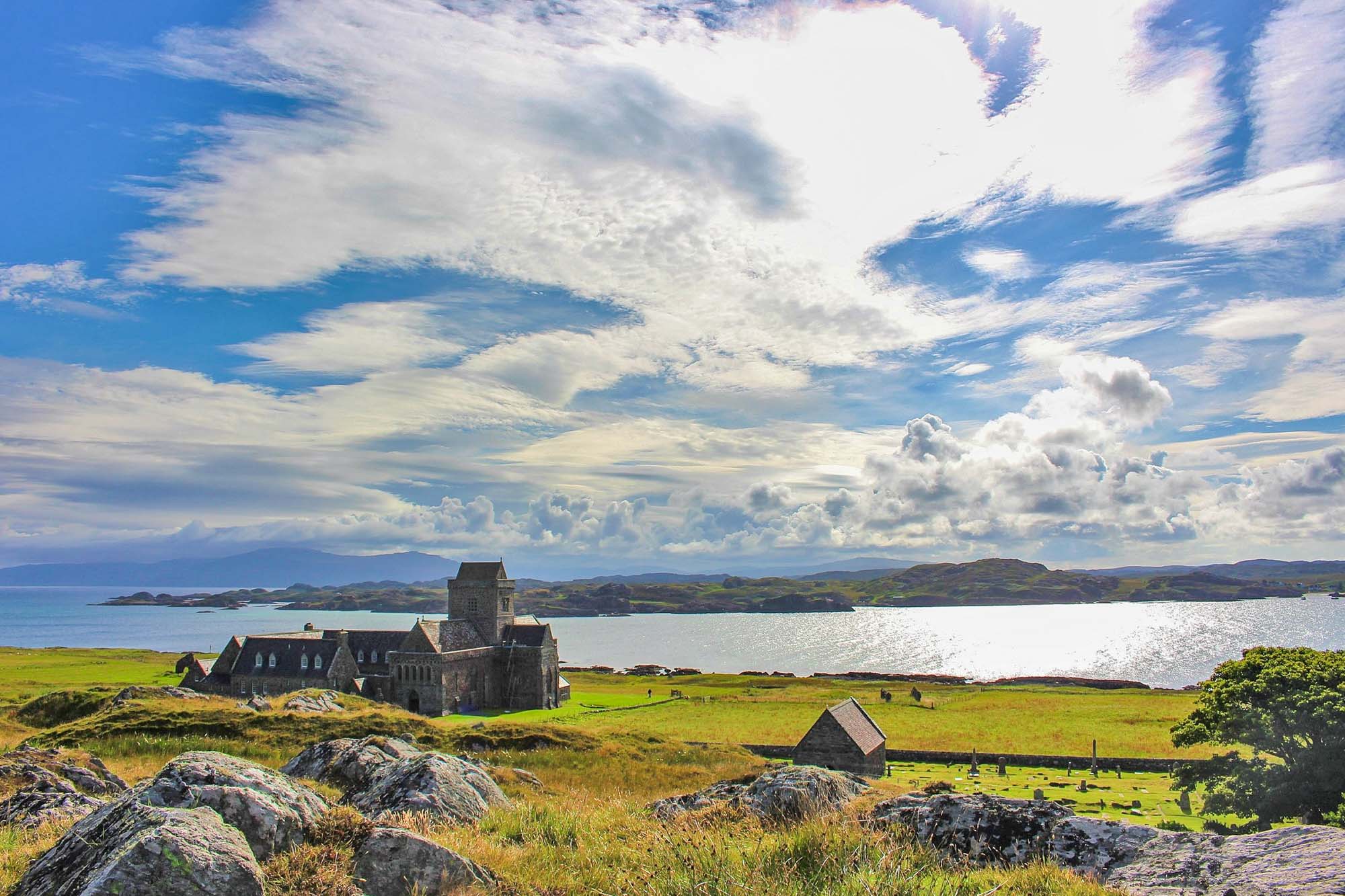
Iona
I have incredibly fond memories of this island as we used to visit regularly when I was a child. Iona is a small island, 3 miles long, nestled into the arm of larger island, Mull in the Inner Hebrides.
To get here, you’ll need to catch a small passenger ferry from Fionnphort, Mull which takes about 10 minutes. No tourist cars are allowed on the island so be prepared to call the island’s one taxi or walk to your accommodation. Iona is home to a population of around 125 full-time residents, two hotels and a scattering of shops.
A series of recent discoveries show that this sacred Scottish isle was not abandoned following the brutal Viking raids of the early 9th Century with monastery life instead continuing and a centre for metalwork being established.
Iona is known as the spiritual home of Scotland’s Christian community due to St. Columba (an Irish monk who brought Christianity to Scotland), who landed here in 563 AD and founded a monastery. His cloisters have become renowned for learning, as monks began Ireland’s treasured Book of Kells here before taking it over to Kells in 807 CE. If you’re interested in history, visit the Heritage Centre, the Abbey & nunnery, the 12th century St. Oran’s Cemetary to see the graves of 60 Scottish Kings such as Macbeth and St Columba’s Bay.
The island is a haven for artists and there’s a number of shops and galleries you can visit here: Iona Craft Shop, Historic Scotland Shop, Iona Gallery & Pottery, Aosdana, Iona pebbles arts and crafts and Oran Creative Crafts.
The island is small enough to walk around, I did this from as young as 5 years old and the beaches here are a true paradise. Some of my favourites are Port Ban, North End and Bay at the back of the Ocean. The highest point of the island (100 metres) is Dun I (pronounced Dun Ee) meaning ‘hill of Iona’ and the view from the top is splendid on a clear day. There is also an old marble quarry which was abandoned in 1918. The huge marble blocks that are left are good for a picnic or hot drink and a small gunpowder house is still standing too.
Iona’s sparse population means that wildlife thrives on Iona. Sighting on seals, otters, peregrine falcons, Minke whales, pilot whales, humpback whales and basking sharks have all been spotted here. Bring your canoes and paddleboards as the eastern side of the island is sheltered and there’s a number of small white sand bays you’ll want to explore.
If you’re looking for day trips whilst here, the uninhabited island of Staffa and the prehistoric Fingal’s Cave is a short boat ride away or take a slightly longer trip out to the Treshnish Isles.
Enlarge
Islay
Islay (pronounced Eye-luh) in the Inner Hebrides is world-famous for one thing above everything else and that’s its whiskey with its distinct smoky, peaty taste.
The best way to reach the island is by car ferry from Kennacraig (Kintyre) to Port Ellen (2 hours 20) or Port Askaig (1 hour 55). On a cloud-free day, the views over Jura are simply astounding.
When you arrive into Port Ellen, you immediately notice large warehouses which are the former Port Ellen distillery. Port Ellen was established as a malt mill in 1825 and then developed as a distillery from 1833 to 1892. These listed buildings give you a glimpse at one of the most important economical branches of Islay and whilst you’re here, you should definitely not miss a tour of a distillery.
Eight distilleries are still active today where you can take a tour of the buildings and experience how the Scottish “water of life” is made. The distilleries of Laphroaig (which holds Prince Charles’ warrant), Lagavulin and Ardbeg can be easily reached on foot from the ferry in southern Port Ellen and are located a few kilometres away. In the northeast of the island near Port Askaig, you will find the distilleries of Bunnahabhain and Caol Ila, in the west Bowmore, Bruichladdich and Kilchoman. Bowmore is the oldest distillery on Islay, founded over two centuries ago in 1779.
Besides the distilleries, Islay island is a good place for nature lovers and the tourist association has created over twenty hiking trails. Anglers, bird watchers and cyclists also get their money’s worth here as the island has 130 miles of coastline and surprises with great, fine sand, beaches and the chances are you will be the only visitor.
The island’s historical sights include the early Christian cross of Kilnave, the chapel of the same name, as well as the ruins of Finlaggan Castle, a former mansion and an important scene of Scottish history. Visit during May’s annual Fèis Ìle, or the Festival of Malt and Music ad you’ll be rewarded with a glimpse of true Scottish island life.
Is there any possibility to island-hop? Absolutely! From Islay, you can do a cruise around the Hebrides and visit other islands in the region. One special destination is Jura, another island famous for Whisky. Only around 180 people live there and the island is only accessible from Islay by ferry.
Written by Phil from Journication. See more from Phil on Facebook.
Enlarge

Isle of Scalpay (Outer Hebrides)
The Isle of Scalpay in the Outer Hebrides is not to be confused with the Scalpay (Skye) in the Inner Hebrides! If you’re researching Scalpay, please make sure you choose the right island otherwise you might be disappointed! This is the island where Bonnie Prince Charlie was given refuge during his flight to Stornoway and over to France after his defeat at Culloden in 1746.
The Isle of Scalpay is located in the Outer Hebrides, nestled into the south-east corner of Lewis & Harris. It is connected to the island of Lewis & Harris by the Sclapay Bridge. The island used to be privately owned by was gifted to the residents by its owner, Fred Taylor, in 2012. Scalpay is around 4 kilometres (2.5 miles) long and rises to a height of 104 metres (341 feet) at Beinn Scorabhaig. The main settlement on the island is at the north, near the Scalpay Bridge, clustered around the North Harbour (An Acairseid a Tuath).
The population is slowly declining and is roughly 250 and there is just one community shop Buth Scalpaigh and one cafe Island Dainties. However, the award-winning North Harbour Bistro is not just another cafe. They do nothing vegan but their menu can be found on Facebook.
The iconic, red and white striped lighthouse of Scalpay, Eilean Glas is one of the earliest lighthouses in Scotland. It used to be lit using whale oil and whales were hunted from this point. It takes about 20 minutes to walk to and from here you will have views over the Minch and Little Minch (which separates the Outer Hebrides from the Isle of Skye) and on clear days you can see the Shiant Islands which are home to huge numbers of nesting seabirds. From here, keep a lookout for dolphins, porpoise, Minke whales and basking sharks.
There’s plenty of self-catering accommodation on Scalpay and also the Scalpay Bothie for campers which overlooks the lighthouse. One thing to note is that the island is ridiculously religious and everything shuts on a Sunday, including the kids’ playpark to observe the sabbath.
Enlarge

Jura
Islay’s nearest neighbour is a spectacular wilderness and rugged beauty where the wintery snow-capped Paps of Jura loom over the landscape. There’s just one small hamlet with its famous whisky distillery and now the island has a Gin distillery too.
Jura is a long and relatively large island; 30 miles long and 7 miles wide. At its peak in the 18th century, the island was home to around 2,000 people, however, these numbers dropped dramatically and now there’s just short of 200 inhabitants.
The island’s only town is Craighouse where you’ll find a distillery and a hotel that overlooks a picturesque beach and to get here you can catch the council-run car ferry from Islay. You can join a distillery tour when you visit Jura but you must book ahead at Lussa Gin and Jura Whisky Distillery. In the town, there’s a community-owned cafe, Antlers, that has a craft shop and displays on Jura heritage.
Some of you may know that George Orwell lived on the island for 6 months in 1946 when he wrote 1984. The house he stayed in, Barnhill Farmhouse is located in the north and can be rented. It’s so remote you’ll need a 4×4 to get there though.
Jura is full of wildlife a visit here will guarantee you sightings of herds of red deer because they outweigh people 25-1. It’s estimated there may be above 5000 red deer on Jura. It’s also a hot spot for white-tailed eagles. The island also has a church with an array of black & white photos and the Jura Music Festival is held in September.
At the very northern tip of Jura, you will find the noisy Corryvreckan whirlpool. The whirlpool is a natural phenomenon caused by tidal flows between the islands of Jura and Scarba. I is the 3rd-largest in the world.
Will you hike the famous three Paps of Jura? Or maybe you’ll fell race and run over the three of them. The tallest pap is Beinn an Oir which stands at a 2,576 feet.
Kerrera
One of the Lorne Islands, alongside Lismore, Kerrera is a small island 400m off the Oban coast. The island is around 7 km (4 miles) long by 2 km wide and is separated from the mainland by the Sound of Kerrera. The north and south of Kerrera island are not connected by road, just footpath. For this reason, the rugged terrain on Kerrera makes it suitable for only mountain bikes and hybrid bikes.
The island is somewhat of a success story and has been able to grow its population by 100% in the last four years. The island has a full-time resident population of 68 which swells during holiday time. The community were also able to purchase the old primary school building in the centre of the island and plan to turn it into a multi-purpose community centre.
A foot passenger ferry is available from Gallanach on the mainland onto the island. It is a small ferry and limited to 12 passengers at a time. The first ferry is at 8:40 am and the last ferry is at 6 pm.
Things to do on the island include hiking to the island highest point Carn Breugach at 189 m (620 ft), watching otters on Slatrach Bay, hiking to the ruined castle of Gylen (Built in 1582 by the Clan McDougall), visiting Horseshoe Bay where King Alexander II died in 1249 and climbing on the shipwreck.
There are not many places to eat on this small island but in the north of the island is the Oban Marina with Waypoint Restaurant and Ardentive Farm selling island produce. In the south, you can visit the Kerrera Tea Garden near the castle.
Near Oban is the Puffin Dive Centre where you can hire gear and book dives.
Lewis & Harris
The Isle of Lewis and Isle of Harris is the main island in the Outer Hebrides. They may sound like two separate islands, but Lewis and Harris are two parts of one island. The boundary
between Lewis and Harris runs for about 6 miles (9.7 km), where the island narrows between Loch Resort and Loch Seaforth. You will find on the island sandy beaches, cliffs on the wild coastline, ancient standing stones, and fantastic Gaelic culture. The largest town is Stornoway on the east coast.
You can get to Stornoway by daily car ferries from Ullapool on the mainland. The port of Tarbert on Harris is linked to Uig on the Isle of Skye by daily ferries so, it’s a perfect idea to combine a road trip between both islands. It’s also possible to get to Lewis and Harries by plane. The island’s airport lies just a few miles from the Stornoway with regular flights arriving and departing from Glasgow, Edinburgh, Aberdeen, Inverness, and Benbecula.
Lewis and Harris Island is a perfect destination for a weekend trip. But you will find activities even for a more extended stay. If you go there on the weekend, it is essential to know that
most shops and businesses are closed on Sunday.
The best way to get around the island is by car or motorhome. The roads are of good quality but narrow. Many of them are single track, with plenty of passing places. It is also bus service between Mondays and Saturday, connecting Stornoway with many of the island’s other settlements. Stornoway is the largest town in the Hebrides with a population of around 8000 people. You will find there also the largest selection of accommodation on the island.
Lewis and Harris island has the most beautiful, wildest beaches in Europe. Soft sand flows between your fingers, and clear turquoise waters resemble a tropical paradise. Only stronger gusts of wind make you realize that this is Scotland coastline after all. You can stroll on deserted beaches for hours.
Calanais Standing Stones are older than the Pyramids and also predate England’s famous Stonehenge monument. Located on the west coast of Lewis, the 5000-year-old Callanish Stones are famous all over the world. They were an important place for ritual activity for at least 2000 years. It is still a mystery why the standing stones at Calanais were erected. Probably it was a kind of
astronomical observatory. The Calanais Standing Stones are an extraordinary cross-shaped setting of stones. They are consist of a stone circle of thirteen stones with a monolith near the middle. When you walk between these Neolithic standing stones, you feel the energy of the secret place.
Apart from hidden sandy beaches, the island offers steep cliffs. The Butt of Lewis has cliffs stretching up to 80 feet high. Violent waves bounce off the jagged coast. The roar of the water often drowns out thoughts. But be careful and don’t go to close to the edge, the area gets winds of up to 100 mph. The Guinness Book of Records named it Britain’s windiest spot.
There are several lighthouses on the island worth seeing. Short routes lead to them. One of the most impressive is Butt of Lewis Lighthouse, famous for red bricks. It is close to the village Poertof Nes. The other one fabulous is the quiet Tiumpan Head Lighthouse at the Eye Peninsula. It is perfect for sunset.
Written by Agnes from The Van Escape. See more from Agnes on Facebook.
Enlarge

Lismore
Lismore or Lios Mòr in Gaelic means the ‘Great Garden’ and is a reference to the damp climate (166cm of annual rain) and fertile ground that amasses here (estimated that there are nearly 300 different types of plants here). Lismore is a 12-mile Inner Hebridean island near Oban. A protected island situated at the mouth of Loche Linnhe, Lismore once supported a population of 1,400 but now only 160 remain.
The island has three spectacular ruins of its own: Castle Coeffin (13th-century hall-house), Achanduin Castle (13th-century castle) and Tirefour Broch (the best-preserved galleried Pictish brochs in the country) and the island has been inhabited since at least 3,500 BC. A stone axe-head was found here and dated & is now in the Edinburgh Museum. There are a number of duns, forts and cairns on the island.
The Lismore Historical Society opened the Gaelic Heritage Museum showing an exhibition of island life and a cafe with a balcony. Adjacent is Tigh Iseabal Dhaidh, a traditional 19th-century cottage. To see the Bronze Age cairns and Iron Age duns visit Balnagown Croft.
To get to Lismore you can catch either a car or passenger ferry. The car ferry from Oban to Achnacroish takes 50 minutes and there are two crossings daily. The passenger ferry takes just 6 minutes and crosses from Point to Port Appin every house.
The Parish Church on Lismore is built from the island’s original cathedral which was burnt down during Reformation. The churchyard has Medieval tombstones and is said to be the burial place of Saint Moluag who came from Ireland in 561AD and created a monastic centre.
Other things to do and see on Lismore include the abandoned kilns, cottages and limestone quarry of An Sailein, Lady’s rock near the lighthouse was the place where Maclean of Duart marooned his wife in 1527. Thankfully she was rescued by local fisherman.
The highest hill on Lismore is Barr Mor (127 metres/400 ft) offering stunning views of Ben Nevis, Port Appin and Loch Etive. Lismore is thus ideal for lazy cyclists and walkers. There are two main towns on Lismore, Achnacroish and Port Ramsay with only scattered residential buildings elsewhere. You can hire bikes here: Lismore Bike Hire
Walking, and cycling, on Lismore offers good opportunities to spot wildlife. The island has an impressive list of birds, around 130 species, and include birds of prey such as owls, hen harriers and buzzards and gulls, shags, guillemots, terns and other sea birds and waders.
| Walk | Grade | Distance | Time |
|---|---|---|---|
| Port Ramsay Circuit (Lismore) |  |
4.75km | 1.5 hours |
| Achnacroish and Salen circuit (Lismore) | |
9.5km | 2.5 – 3.5 hours |
| Achadun Castle, from Achnacroish | |
13km | 3.5 – 4 hours |
| Tirefour Broch and Castle Coeffin from Achnacroish | |
11km | 3.5 – 4.5 hours |
| Castle Coeffin and Tirefour Broch from Point | |
15km | 4 – 4.5 hours |
Luing
Luing is part of the Slate Islands and it lies 15 miles south of Oban and a short ferry trip across the Cuan Sound from neighbouring Seil Island. Luing is 6 miles long and 1.5 miles wide, has two picturesque villages and stunning views over to Belnahua, Scarba and the Garvellachs. It is an ideal location for cycling and has a diverse variety of wildlife, including otters, hares, seals, porpoise and dolphins. There are also regular chances to see buzzards, peregrines, hen harriers and eagles.
Cullipool is the islands largest town where rows of cute, white cottages with colourful doors line the streets and overlook the flooded slate quarries. Cullipool has wonderful sunsets framed by the islands and with the grey slate reflecting all the colours of the sunset. From here you can visit the remains of Kilchattan Church, Kilchattan Chapel, Kilchattan graveyard and the Atlantic Islands Centre.The building sits of the edge of a flooded slate quarry and you’ll find exhibits about the islands’ wildlife, geology, and slate industry. Upstairs is the Luing History Exhibition with a cafe and gift shop.
The best way to explore this island is by bike and you can hire them from the Sunnybrae Caravan Park. The island’s highest point is Cnoc Dhomnuill which is only 94m above sea level! There’s a strange rock formation above a beach called the Cobblers of Lorn and many low level, beach walks and the Luing Store gives out walking maps if you want one.
Muck
The Isle of Muck is the smallest of four islands in the Small Isles with its neighbours being Eigg, Rum and Canna. It’s another eco-friendly island and all of its electricity is provided by wind turbines and photovoltaic solar panels from the island.
Ferries leave from either Mallaig or Arisaig and cars are not allowed on the island at all. You’ll be collected from the port, sometimes on a tractor which is exciting, however, the island is only 2.5 miles long by a mile wide so it’s not hard to cover on foot. If you’re feeling brave enough you could hire an offshore RIB operating from Elgol on Skye to both Rum and Canna. Advance booking necessary, telephone 01471 866 244. Arisaig Marine runs cruises lasting 2-5 hours ashore Eigg, Muck and Rum. Operating from April until late September and departing Arisaig at 11am. YOu must pre-book, telephone: 01687 450224. The harbour office at Arisaig also contains a tea room, showers, toilets, shop and a laundrette.
There are just 40 inhabitants on Muck so there are more cows than people but some things you can do are visit the Craft Shope and Tea Room, see the school & community hall, take meandering walks down to the beach at Cairidh Bay and look for seals at Port Chreadhain.
Some of the spectacular views from here include from Gallanach Bay overlooking Horse Island where a Puffin colony lives. The island has some semi-wild horses and lots of other wildlife including whales, sharks, dolphins, porpoises & otters and bird-watching includes puffins and eagles. You could walk up to Beinn Airein (425ft) and view the other Small Islands. If you’re looking for a more challenging walk, approach from the west side.
There’s no shop although you can buy produce from honesty boxes. These are mostly meat and eggs though so if you’re vegan you’ll need to take all of your food across with you. There’s limited accommodation on Muck and you’ll need to book well in advance. Gallanach Lodge and Port Mor Guest House offer evening meals
Charters to other islands are also possible. There are three cottages to rent on Muck and one bunkhouse and they’re all run by the community. Best to contact them on Facebook for availability.
Enlarge

Mull
The second-largest island of the Inner Hebrides, Mull has a craggy coastline and is easily accessible from the mainland by ferry ports Oban, Lochaline and Kilchoan. Mull is most well known for its brightly-coloured houses in Tobermory, home to the fictional children’s TV series Ballamory. If you’re visiting Tobermory, there’s also a fine whisky distillery producing the excellent Tobermory and The Isle of Mull Brewing Co.
St Columbus landed in Mull from Ireland in 563 AD and established a church to convert the pagan Scots. It’s lost its place as a spiritual pilgrimage and instead is full of hikers, canoeists and nature lovers. On Mull, you can see puffins, dolphins, whales, seals, otters, deer, highland cows and birds of prey such as white-tailed sea eagles which are the largest and rarest bird of prey in Britain.
The isle of Mull is shaped like a mini Great Britain on its side, is the fourth largest Scottish island and has an area of 338 square miles. The coastline of Mull is almost 300 miles long and home to six castles. Duart Castle, Torosay Castle, Moy Castle, Aros Castle and Dun Ara Castle are all open to the public.
The pyramid mountains of Ben More and Stob Binnen tower over parts of Mull and will test all but the most experienced walkers but there are tons of walks and hikes to be done on Mull that are not as taxing; Aros Park and its waterfall, Calgary Bay, Lochbuie to Carsaig, Lochbui standing stones and MacCulloch’s Fossil Tree are all cracking walks that take in Mull’s amazing natural charms. Seven Mull walks for everyone details some more walks around Mull.
Mull has some classic Inner Hebridean beaches featuring white sand and wind-swept bays. Calgary Bay has ruined settlements, iron-age forts, a white shell beach and a cafe, Uisken has views out to Colonsay and the Paps of Jura, Port na Ba is gaelic for Beach of the Cattle, Laggan Sands was voted the 9th best beach in the UK for wildlife spotting but our favourite is Traigh Ghael (Gaelic for white beach). Uisken Beach has a family-friendly Beach Games day in August.
If you prefer to spectate July’s Tobermory Highland Games. with its caber-tossing, hammer throwing and tug of war is fun and October’s Tour of Mull Car Rally is loud!
If Mull isn’t enough, you can take day trips to both the Isle of Iona or the Isle of Ulva.
Enlarge

Orkney
Orkney is an archipelago of 70 islands off the northeast coast of Scotland, the largest of which is called Mainland. Just 20 of the islands are inhabited, nearly half of which live in the capital of Kirkwall.
My trip to Orkney was the last stop on a car camping trip around Scotland and I believe we saved the best for last. Orkney is a rugged place packed with beautiful sea-scapes and over 5000 years of history.
Despite being seemingly remote, Orkney is actually quite straightforward to reach either by ferry or by flight. The ferry from John O’Groats to Orkney takes less than an hour as do flights from all the major Scottish cities. Once on the island, the best way to get around is by car, since the sites are quite spread out. Several days are required to take in all the sights around mainland and Stromness is a good base from which to explore.
Orkney is a top place to visit if you’re interested in ancient historical sites. There are a group of Neolithic sites inscribed by UNESCO, which are collectively known as the Heart of Neolithic Orkney. At the top of the list is Skara Brae. Skara Brae is a 5000-year-old village and one of the world’s best stone-age sites. Then there’s Maeshowe burial chamber whose entrance passageway is precisely lined up with the setting sun on Winter Solstice. Finally, there are the spectacular stone circles of the Ring of Brodgar and the Standing Stones of Stenness, which give Stonehenge and Avebury a run for their money.
Orkney also has a strong Viking history and genetic studies have found that many Orcadians are descended from Norse people. One of the most iconic Viking sites on Orkney is the beautiful St Magnus Cathedral in Kirkwall. This is the most northerly cathedral in Britain. Nearby you can also visit the ruins of the Earl and Bishop’s Palaces.
In order to appreciate the rugged coastline of Orkney, head over to the west of the island and visit Yesnaby. Here you can marvel at the incredulous sea stacks that are being constantly eroded by the elements. Further to the north, you can visit also the tidal island, the Brough of Birsay, which is accessible for 2 hours either side of low tide. This is a top place for spotting puffins in the summer months.
Written by Lou from Wandering Welsh Girl. To see more from Lou, head over to her Instagram.
Pabay
Only 21 people live on this privately owned island located a short distance from the Isle of Skye that sits across the Broadford Bay. There are no ferries and its one of five islands known by the exact same name which makes it very confusing! This island is in the Inner Hebrides and is not Pabbay which is in the Outer Hebrides.
The name Pabay is derived from an old Norse word meaning “priest’s isle” and there are the remains of a 13th-century chapel on the island. Pabay is roughly 360 acres in size, diamond-shaped and incredibly flat with the highest point (the beacon of Sgeir Gobhlach) being just 28m/64ft above sea level. Pabay is known for its unique geology consisting of fossils, Pabba shale and other features. The shoreline at low tide almost doubles the area of the island revealing many geological features including specimens of petrified fish and shells.
Ruins of the 13th-century chapel foundations remain but it is not certain to what saint the church was dedicated. The chapel is small, measuring just 21 feet in length and there appear to have been two other buildings nearby. The most preserved building is an irregular semicircular structure of uncemented stones of large size measuring 9 x 6ft. Little is known about it. The chapel, built originally by St. Columba’s monks fell into disrepair after the monks left when it became a refuge for outlaws ‘broken men’ and robbers.
Pabay is a flat island with mostly heath, dry grassland, herb marsh, salt marsh, woodland remnants and with the new additions of 75 acres of freshly planted deciduous and coniferous trees, containing 17 different species. For such a small island, it boasts 32 different species of wildflowers, 49 herbs, 40 kinds of grass, sedges, ferns and rushes.
Some of the island inhabitants are otters, seals, 32 breeding bird species and 72 non-breeding birds. There is also a large (semi-uncontrollable) rabbit population and shrews have also been seen.
Interestingly and uniquely, Pabay has a licence to produce its own stamps and in 1996 the island’s owners were paid £1,260 a year by the Post Office to collect and deliver their own post over the sea to Skye. It was last up for sale in 1996 and the description read “Pabay has everything “isolation, privacy and accessibility”. The £395,000 includes 326 acres, a farm with wind and solar power, a harbour, a jetty, and a willing boatman who needs just £50 (plus VAT) to take new residents the two miles to the island from Broadford on Skye.”
Raasay
If the Isle of Skye is just too busy for you, head to its smaller sister Raasay! Raasay measures 14 miles by a little over three miles and it has only 170 inhabitants, one distillery andone hotel. It is also described as one of the most geologically diverse landmasses in the world. To the north, the island is surrounded by even smaller islands including Rona, Eilean Fladday (Fladda) and Eilean Tigh.
Raasay (Ratharsair in Gaelic) means Isle of the Roe Deer and to get to Raasay, you’ll first need to go to Sconser (Skye) and catch on of the 9 daily ferries. It is a great island to visit for hiking, cycling, kayaking, birdwatching and generally just getting away from the world. The largest animal on the island is the red deer but other animals include voles, rabbits, otters, seals, dolphins, porpoises, minke whales and orcas as well as white-tailed eagles (sea eagles), golden eagles, buzzards, hawks, tawny owls, starlings, and flycatchers.
The island’s shops are limited to a quirky take-away in a shipping container, The Larch Box (summer months only) and the small Raasay Community Stores in Inverarish. If you’re not staying at the Raasay Hotel, there are a number of AirBNB’s however you can wild camp with a tent. Other shops on the island include The Silver Grasshopper, a silver jewellery artist, The Studio run by an artist and photographer and of course the Isle of Raasay Distillery which produces Whisky & Gin using 10 botanicals, including Raasay juniper. It also employs over 10% of the island’s population.
Other things to do and see on the Isle of Raasay include the Battery, a fortified gun emplacement from 1809 which has stone statues of busty mermaids to accompany it, the cleared villages of Hallaig and Screapadal, the ruins of 15th-century Brochel Castle, Calum’s Road (a 10-mile road built entirely using a hand pick), Rainy’s Wall, St Moluag’s Chapel, the old mining works, Pictish Stone, Dolmen at Eyre Point, Storab’s Grave, and Oar Cave.
Hiking Dun Caan (444m or 1,457ft) is about 9.6 miles/15.5 km and takes approximately 5 hours. A shorter walk is Temptation Hill which is a roughly 2-hour walk where you’ll see the Pictish stone & Iron Age broch along the route. Cycling is becoming more popular since the 10-hour endurance race, Raasay Rumble, took place. You can rent a bike from Raasay house but you’ll need to pre-book.
Nice beaches to visit are Inver Beach and North Bay and there are also two tidal islands you can visit at low tide. However, Raasay House Hotel offers a number of adventure activities including Coasteering, Kayaking, Gorge Walking, Abseiling and Rock Climbing.
Rona (North) & Sula Sgeir (abandoned)
This incredibly remote Scottish isle is now only inhabited by seals, birds and the sad memory of a tragic settlement wiped out by a series of unfortunate events.
Rona North is located to the far north-west of Scotland with no other island for neighbours. The island lies 71 kilometres (44 miles) north-west of Lewis & Harris (Outer Hebrides) and 18 km (11 miles) east of Sula Sgeir. More isolated than St Kilda, it is the most remote island in the British Isles ever to have been inhabited on a long-term basis. Its closest neighbour is actually the Faroe Islands and due to the island’s remote location, it is frequently omitted from maps of Great Britain and the United Kingdom.
Few people have been to this island which makes it all the more exciting to visit. Landing here is only possible in excellent conditions and it could take between 3 and 6 hours to reach from Lewis & Harris. North Rona is just a mile and a half long and has one hill of 108 metres (354 ft), Toa Rona which descends westwards to become a ridge which in turn slopes down to the sea in rocky promontories.
Rona was probably the residence of Saint Ronan in the eighth century. He built a christian oratory built of unmortared stone which survives today – the best-preserved structure of this type in Scotland. There continued to be inhabitants through the middle ages but sometime around 1685, the entire population of 30 people was wiped out. There appears to have been a shipwreck close by and rats from the ship were able to make it ashore Rona, devouring all of the crops and possibly passing disease to the residents. Either way, they died of starvation or bubonic plague. A couple of centuries later, the island was home to a collection of monks and what is likely to be their stone-marked graves are still visible today.
Together with Sula Sgeir, the island is a nature reserve for its important grey seal and seabird colonies. The grey seals use the labyrinth of sea caves along the coast for breeding and shelter. The island is the third-largest breeding ground for grey seals in the United Kingdom. It is also important to the local populations of sea birds including black-billed gulls, puffins, kittiwakes, and guillemots.
Paul Murton is one of few people to visit and document his travels there. He left from the tiny port of Miavaig on Lewis on what they expected to be a 3 hours journey. Instead, with rough seas, it turned out to be a 6-hour journey with his crew using 25 out of the 28 seasick bags provided! In “Island at the edge of the world”, poet Kathleen Jamie describes a visit to Rona leaving from Kinlochbervie on the Scottish mainland. The skipper warned it would be a bit rough and the crossing lasted six hours across the dark blue sea.
Rona is also integral to Peter May‘s Lewis Trilogy commencing with The Black House (The Lewisman and the Chessmen).
If you’d like to visit Rona and Sula Sgeir you can catch a cruise with Northern Light,North Coast Sea Tours, andIsland Cruising.
Rona (South)
To the east of Skye and the north of Raasay, lies the small island of Rona at 5 miles long. No ferries run here so you’ll need to find a private tour or boat operator.
Rona has a permanent population of just two and three unique & stylish shoreside holiday cottages with the whole island yours to explore! The cottages are hidden away in Dry Harbour, a mile’s walk over the hill from the jetty at Big Harbour.
Rona is an incredible place to escape just about everyone and is a natural paradise. The island of Rona boats a cave, croft ruins, an abandoned village, an incredible coastline, red deer, otters, seals and basking sharks. There is even the island’s own bottling of Edradour whisky.
The northern part of the island is occupied by the Ministry of Defence (Boo!) but if you take a wetsuit you can easily swim and paddleboard around. One of the island’s big draws is its absolute lack of roads, shops and streetlights and thus the night sky on a clear night is phenomenal.
The book ‘Whirligig Beetles and Tackety Boots‘ was written by Julia MacKenzie, an ex-Rona resident, although I am unable to find a copy for sale.
See more from this amazing island on Facebook.
Enlarge

Rum
One of the Small Isles in the Inner Hebrides located south of Skye,the Isle of Rum is eight miles long, shaped like a diamond and pedestrianised. Visitors to Rum are not permitted to bring vehicles but bikes are fine! If you want to hire a bike whilst there, pre-book with Rum Crafts at fliss@isleofrum.com.
The main ferries leave from Mallaig (1.5 hours)and prior to this, you could pop into Fort William and see the Glenfinnan Train. If you’re feeling brave enough you could hire an offshore RIB operating from Elgol on Skye to both Rum and Canna. Advance booking necessary, telephone 01471 866 244. Arisaig Marine runs cruises lasting 2-5 hours ashore Eigg, Muck and Rum. Operating from April until late September and departing Arisaig at 11 am. You must pre-book, telephone: 01687 450224. The harbour office at Arisaig also contains a tea room, showers, toilets, shop and a laundrette.
The only village on the island is Kinloch which was bought out by the 35 villagers who live there in 2009 (although they’ve been recruiting for more). The rest of the island is owned by Scottish Natural Heritage. Rum is magnificently wild and rugged so if you’re looking for true natural beauty, you should head here. Visitor accommodation on Rumincludes bothies, B&B, hostel, campsite and glamping huts. The Kinloch Village Campsite is on the waterfront and includes a small wooden shelter, toilets, hot shower and freshwater. You’ll need all camping equipment if you camp or stay in the pods.
There are two mountain bothies about 3 hours walk from Kinloch village. They are maintained by the Mountain Bothy Association and offer basic facilities. Dibidil Bothy has a wood-burning stove and bunks whilst Guirdhil has an open fire and a raised wooden platform for sleeping. You’ll need to bring ALL camping equipment as well as fuel for cooking. You are allowed to wild camp in a tent on Rum but observe a few basic rules!
In Kinloch, you’ll find the Kinloch Castle which was finished in 1900. The stone was imported from Arran and the gardens are rooted in 250,000 tons of Ayrshire topsoil. You can book a tour to see the opulent interior. There’s also the impressive Bullough mausoleum. Built in a classical Greek style it seems a bit out of place in the Hebrides. It is possibly the only Doric temple in the Highlands and Islands.
Rum great for hiking, scrambling, biking and running. The footpaths along the coastline are flat ground and great for wildlife watching but the south-east of the island is dominated by the Rum Cuillin, a mountain ridge that is made up of the peaks of Barkeval, Hallival, Askival, Trollaval, Ainshval and Sgurr nan Gillean. For a full day tour try to take in the peaks of Hallival and Askival; if you have more time, base yourself at Dibidil bothy and hike the various peaks of the Cuillin from there. Alternatively, the route to Kilmory Bay in the north is a 16km walk, passing the Kinloch Glen Waterfall and ending at a gorgeous pink, sandy beach overlooking the Atlantic. There are also two caves on the island for you to find. There are two roads leading from Kinloch to Kilmory and Harris Bay, which offers a total of 11 miles of cycling.
Essential visits are to the Rum Visitor Centre where you can learn about the island’s geology, walking routes and pick up some useful leaflets. It is located by the Old Pier and is open every day during the summer months. There is a small village shop that is usually open in the mornings and evenings and sells basic supplies and Kim’s Kitchen, which is housed in the community hall in Kinloch. There are a number of craft shops where you can buy locally produced arts and crafts and pay for souvenirs at honesty boxes: Rum Crafts, Tattie House Crafts, Croft 3 in The Shed.
Other adventurous activities include a mini pelagic boat tour with Rum Ranger Trudi. Tours run on Thursday afternoons between April and September when the MV Sheerwater from Arisaig drops sightseers off on the island. On Thursday afternoons you can also join a 2 hour guided kayak tour to the Island of Soay
Wild red deer and semi-wild ponies roam free and a colony of around 200,000 Manx shearwater seabirds breed on Rum. There are a number of Otter Hides on the island with the most easily accessible being at Loch Scresort. Ponies are most tame around Kinloch Castle and have been recorded on the island since 1772.
| North Side Trail, Kinloch | |
5.5km | 1.5 hours |
| Port na Caranean | |
2.5km | 1 hour |
| Kilmory Bay | |
18.5km | 4 – 5 hours |
| Out-and-back walk to Harris from Kinloch | |
24.5km | 6 – 7 hours |
| Hallival and Barkeval | |
13.5km | 5 – 7 hours |
| Orval, return via Harris | |
27km | 8 – 8.5 hours |
| Rum Cuillin traverse | |
21.5km | 12 – 14 hours |
Enlarge

Scalpay by Skye
The Isle of Scalpay by Skye is privately owned and operates a red deer farm, shooting estate and holiday cottages. Much of Scalpay is covered with heather, while other areas are conifer forestry plantations. On a clear day, the view from Scalpay by Skye will take in Pabaay, Raasay and Skye.
There is a permanent population of just four people on Scalpay by Skye and the island boasts 14 miles of shoreline. There are also only three cottages on the island to let between April and October.
Some of the walks on the island include visiting the waterfall beyond the largest loch, Loch an Leoid and a scenic walk along the cliff path with views over the neighbouring islands of Longay and the Crowlin Islands. For history enthusiasts, there is an old Viking Settlement on the island.
Otters are prevalent on this near-deserted island as are red deer, voles, weasels, stoats, fox, bats, seals, porpoise, dolphins and occasionally all types of whales.
Enlarge

Seil
The Slate Islands are an island group in the Inner Hebrides, lying immediately off the west coast of Scotland. The main islands are Seil, Easdale, Luing, Shuna, Torsa and Belnahua.
Seil Island is located half an hour drive south of Oban and is accessed via the 18th-century humpback Clachan Bridge, popularly known as the ‘Bridge over the Atlantic’. It was built in 1792 for the whopping sum of £450. Beside the bridge is a pub, Tigh an Truish, or ‘House of the Trousers’, where islanders would have to swap kilt for trousers in order to conform to the post-1745 ban on the wearing of Highland dress & kilts.
The main settlement on the eastern side of Seil is Balvicar, now home to the island’s main harbour. Here you’ll find the Balvicar Stores, Seafari Adventuresand Sea Kayak Scotland. The south of the island finds Cuan where you can get the ferry over to Luing.
The largest village on the island is Ellenabeich, in the west, which is picturesque with its hillside backdrop and rows of white-washed, 19th-century workers’ cottages. Ellenabeich is also where you’ll find the Oyster Bar & Restaurant, the Easdale ferry, the Heritage Centre and the departure point for the Seafari trips to the Corryvreckhan whirlpool.
The village’s main attractions are the gardens of An Cala with its glorious azaleas and Japanese flowering cherries in early summer however the heritage Centre is definitely worth a visit as it details historic island life and even provides archives to help with tracing genealogy. It also sells gifts and beautifully painted slate souvenirs.
From Clachan Seil you can walk past the Tigh an Truish hotel down to the Puilladobhrain Anchorage. A great walk and you’l likely see deer, goats, seals and otters whilst there. This is also a great spot for kayaking.
From Seil you can take a day trip to Easdale and Luing and the other Slate Islands.
Enlarge

Shetland Isles (Mainland)
The Shetland Islands, previously known as Zetland which is why the postcode starts ZE, are the UK’s hidden secret. Most tourists don’t make it up there because it’s too far or it’s too cold or they don’t have time but I promise you that if you visit these ancient islands, a true adventure awaits you.
The Scottish archipelago of Shetland has over 100 islands but only 15 are inhabited. The islands lie 80 km (50 mi) to the northeast of Orkney, 170 km (110 mi) from the Scottish mainland and 300 km (190 mi) west of Norway. Although they’re far away, the population currently totals 23,000.
Humans have lived in Shetland since the Mesolithic period roughly 4,000 years ago although the islands didn’t become part of Scotland until the 15th century. The Shetland Islands have a unique culture, language and even have their own flag. The colours are identical to those of the flag of Scotland but are shaped in the Nordic cross. The Shetlands are perhaps most famous for their firey festival, Up Helly Aa in January.
The largest island, known as “Mainland” is the third-largest Scottish island and the fifth-largest of the British Isles. It is shaped somewhat like a number 7 and its capital is Lerwick which is very pretty and features quirky lanes. From here you can take a walk down to The Knab and watch whales. Mainland is home to Europe’s largest sandy beach with sea on both sides; St Ninian’s isle. It is a phenomenal sight to see and it’s no surprise that Shetland was awarded Lonely Planet’s Best in Europe 2019 as one of Europe’s top destinations.
In order to geet to Shetland, you’ll need to either fly, take the overnight ferry from Aberdeen to Lerwick (12 hours) or the ferry from Kirkwall, Orkney to Lerwick.
In the south of Mainland, you’ll find the Croft House Museum, a 19th century thatched roofed cottage which depicts Zetland life in the 1800s, Jarlshof Prehistoric And Norse Settlement, a goldmine of 4,000 years worth of history which was revealed after a ferocious storm battered the headland. Here you’ll find a Bronze Age house, Iron Age broch and wheelhouses, Norse longhouses, a medieval farmstead and a laird’s residence from the 1500s and RSPB Sumburgh & the 1821 lighthouse. This area has an abundance of killer whales and puffins, so stay alert!
In Lerwick, you can also visit the Shetland Museum which is found in the historic Hay’s Dock. We recommend coffee at The Peerie Café and you must photograph the Lodberries. Built in 1730 these stone cottages built into the sea make great photos. Thirsty? Stop off at the Lerwick Brewery and sample their most popular beer, the 60° North Lager. Wildlife boat tours leave daily from Lerwick Pier giving you a chance to see Shetland’s vast number of sea birds as well as porpoise, dolphins, otters, seals and whales.
Scalloway Castle is a short distance from Lerwick and its history is riddled with drama and bloodshed. Mousa Island is located to the south-east of Lerwick and holds the best-preserved iron age broch in Europe. It’s 2,000 years old and if you have the chance definitely worth making the trip over.
Mainland is definitely not short of things to do and art is well celebrated. Take a trip up to Bonhoga Gallery which is situated in Weisdale Mill built in 1855.
The Fethaland High Cliffs are to the furthest north of Mainland and here there are ruins of buildings and a magnificent beach. With a walk of about 4.5km, you can see the lighthouse. If you’re up for some adventure, go on a kayak tour with Sea Kayak Shetland. We recommend a trip to the red granite Ronas Voe fjord. You’ll get to visit The Blade beach and kayak through sea stacks and caves. Alternatively use Adventure Shetland and visit Uyea; a set of phenomenal small islands with the bluest water. As a bonus, you’ll be the only person for miles around!
Shetland has 1,697 miles of coastline, making it a dream for recreational divers and with diverse coves, caves, inlets, stacks, subterranean passages, historic wrecks and amazing wildlife, there’s plenty to ‘sea’!
If you can’t dive but still want to see under the water, Seabirds and Seals boat tour include underwater viewing with a remotely controlled tethered mini-submarine that feeds live colour video images onto display screens in the cabin.
Enlarge

Shiant Islands (Uninhabited)
Although their formal name is Na h-Eileanan Seunta, which means the charmed, holy or enchanted isles, these islands are also referred to as the Bewitched Islands supposedly as they continually change shape according to the weather and visibility which is often poor.
The Shiant Islands are a privately owned island group in the Minch, east of Harris in the Outer Hebrides of Scotland. They are five miles southeast from Harris and approximately 12 miles northwest of Skye.
Over the course of the past 1200 years, the islands have had multiple landlords from the Vikings to author Sir Compton Mackenzie. They were continuously inhabited until the start of the 20th century (when there were 8 full-time residents) although it is now uninhabited. The islands were owned recently by Adam Nicolson who gifted them to his son, Tom, for his 21st birthday. The island only has one small bothie on it.
The main islands are Garbh Eilean (rough island) and Eilean an Taighe (house island) which are joined by a narrow shingle beach. Although Eilean an Taighe was previously called Eilean na Cille (island of the church) prior to the 19th century. There’s also Eilean Mhuire (island of the Virgin Mary) to the east.
The islands have the same rock formation as Staffa Island with black, basalt columns rising high out of the sea for nearly 500 feet. With similar features, there’s also a small cave known as the ‘Doorway of the Seals’ where you can see seals frolicking in the water and basking in the sun. This area is also a hotspot for Dolphins jumping in the waves.
Added: The Shiant Islands are a haven for wildlife with over 300,000 seabirds, including puffins, guillemots, razorbills, shags and great skuas. around 10 per cent of UK puffins and 7 per cent of UK razorbills breed here every year. It is estimated that there are between 15,000 and 18,000 guillemots, 8,000 to 11,000 razorbills, between 4,000 and 6,000 fulmars, 2,000 kittiwakes, roughly 1,500 shags, a few hundred gulls of various kinds (whose numbers are rising), 26 great skuas and 240,000 puffins. In July 2009 Europe’s oldest puffin, aged 34, was discovered on the Shiant Islands.
You can either visit the island on a tour or arrange your own charter and stay on the island. You must first contact Tom for permission (tom@shiantisles.net) although there is no charge for staying. The house is described as extremely basic with no electricity, running water, telephone or toilet however Katie Tunn managed to spend a whopping 37 days on the island. There is a mobile phone signal but you obviously can’t recharge them without solar packs.
If you want to visit the Shiant Islands, you can tour with Hebrides Cruises, Sea Harris, Isle of Harris Tours or Hebridean Whale Cruises.
Enlarge

Skye
When it comes to awe-inducing islands in the Scottish Highlands, the Isle of Skye is one of the most photographed and most sought after locations on a road trip through Scotland! With the island being connected to the Scottish mainland via the Skye Bridge, it’s also one of the most easily accessible islands in Scotland.
Many travellers spend three or fewer days in the Isle of Skye, but if you want to be thorough and really get to the good stuff, you should spend a minimum of five days in this area. Honestly though, once you arrive, there is a very slim chance you’ll want to leave, so add on those days and thank me later!
To explore this island in the best way possible, you should either rent your own car or campervan. A lot of people base themselves in Edinburgh or Glasgow, so look in those cities for the best, and cheapest car rentals. The drive from both Edinburgh and Glasgow to Skye is roughly four hours, but it’s incredibly scenic and there are plenty of places to stop and see on the way there like Glencoe Valley and Glenfinnan Viaduct, AKA the Harry Potter Train! There are guided tours that can take you into Skye, but a lot of your time is limited since you’re travelling with a larger group and you won’t get to see as much on these group tours. Plus, it’s so much cheaper to ‘DIY’ your itinerary anyway. Save your coin and see so much more!
With those robust five days on your itinerary to work with, you’ll for sure want to include these epic, highlighted stops: Eilean Donan Castle, Glencoe Valley, the Neist Point Lighthouse, Old Man of Storr, Glenfinnan Viaduct, Kilted Rock, the Fairy Glen, and the Quiraing.
From the Isle of Skye, there are even more island-hopping opportunities to take advantage of. If you have limited time on Skye, I recommend exploring this island as thoroughly as you can before taking on another, however, if you’re adventurous and want to see the best of the best, you can board ferries from the Isle of Skye to access the Outer Hebrides, Raasay, and the Small Isles. If you’re interested in exploring these untouched areas, book your tickets and view the ferry schedule here.
Written by Aaren from What Do You Sea. Read more from Aaren on Facebook.
Soay
Just off the south coast of Skye, lies a tiny island called Soay. It currently has a population of three and Soay, whose name is derived from the Norse “sheep island”, has always been lightly populated. The population rose after the Highland clearances and in 1851 the population reached a peak of 158 people. It then dwindled steadily and in 1953 the remaining population of 27 asked to be moved to new homes on Mull.
Soay is inaccessible to most travellers as there’s no ferry. You must arrange a private transfer or a tour as the island can only be reached from Elgol on Skye, four miles away, or Mallaig 15 miles away. The island is a rough figure-of-eight shape, four miles long by two miles wide and the highest point is Beinn Bhreac (140m). The island of Soay has no mains services, shops, jetty or proper road and no public at all.
One of the inhabitants of Soay is Anne Cholawo. A graphic designer, she moved to Soay from London after seeing a cottage advertised in a shop window on the Isle of Skye. Anne went on to write a book about her new home, called ‘Island on the Edge – a life on Soay’. The island now boasts an incredible love affair and a story of success because a year after Anne’s move to the island, the Royal Marines agreed to airlift her piano from the main island using a Sea King helicopter. This is how Anne met her future husband and the couple married in 2005.
Sadly, the island could stop the closure of its beautiful, stone-built, primary school, despite a huge fight to preserve it and it was finally sold in 2015. The building stands on a raised shingle beach where Vikings used to haul their longships.
If you’d like to visit this almost forgotten Isle of Scotland, watch an otter trying to eat a crab on the beach or watch the pods of dolphins majestically leaping around its bays, you can book a tour with Misty Isle Boat Trips or Bella Jane Boat Trips.
Staffa (uninhabited)
Staffa is 7 miles west of Mull and 6 miles north-east of Iona. It’s only half a mile long by a quarter of a mile wide and now completely uninhabited although in the 1700s, 16 people lived there. The Isle of Staffa can be accessed by boat tours from Fionnphort, Ulva Ferry, Iona, Tobermory, Oban and Kilchoan.
There is perhaps no other site that is so great and as mesmeric as approaching Staffa with its enormous basalt columns flanking the deep caves. Staffa is a volcanic island and the basalt columns formed when a single lava flow cooled around 60 million years ago. If the sea is calm, you should be able to float into Fingal’s Cave and dock. You’re able to explore the island although watch out for its steep sides!
The whole island is dotted with caves and is now are home to black guillemots, fulmars, puffins and the magical Fingal’s Cave puffins that nest in burrows on top of Staffa’s high cliffs. Keep your eyes open for Minke whales, dolphins, basking sharks, grey and common seals and porpoise. Not forgetting some of the smaller species such as the huge variety of plankton that forms the base of this very important ecosystem, crustaceans and jellyfish.
Fingal’s Cave is 72 feet tall and 270 feet deep and if you’re feeling adventurous, you can wild swim in it. Basking Shark Scotlandoffers a bespoke ‘Swim Fingal’s Cave’ tour, where you can swim or snorkel into the cave. Floating into the mouth of the cave, looking straight up the basalt pillars and rock formations is impressive enough but if you snorkel, you can see the colonies of marine life underneath you too! If you don’t want to swim, you can also kayak into the cave.
The composer, Mendelssohn is one of the island’s many famous visitors and after visiting he wrote ‘The Hebrides Overture’ in 1832. Its other famous visitors include Queen Victoria, William Wordsworth, John Keats, Lord Tennyson, Jules Verne, Pink Floyd.
Enlarge

Stroma (Abandoned)
Stroma is a short distance from John O’Groats and is now fully abandoned. The island is privately owned but the owner, William Simpson, will take you over for the day for a small fee. Contact here for details. He farms sheep on the island and stays over there for a month during lambing.
In order to get to Stroma, you’ll need to cross the Pentland Firth which is lethal with rushing waters during the tides. Stroma, apparently, translates as ‘island in the stream’ although island in the perilously dangerous waters would be a better description.
Until the early 1900s, the island of Stroma was well populated but the final resident left in 1962 leaving on the lighthouse keeper until 1997.
Once we were on the island we had just over 3 and a half hours to explore. Of course, the priority was the lighthouse so we set off, deciding that we
Things to do on the island include seeing the lighthouse and the presence of the old foghorn buildings, the two towers on the island of Muckle Skerry, the largest of the Pentland Skerries, an old pier and slipway with a rather rusty boat looking ready to be lowered into the sea, the old harbour, a war memorial and of course the derelict houses.
The houses are in varying states of dereliction. Some with their windows and roofs intact others with decrepit walls
Almost immediately the derelict houses appeared, all in varying states – some with their roof and windows semi-intact and others with no roof, windows and barely any walls at all. Only one house still looks intact, the one next to the old manse, which has a bit of a run down telephone box in front of it – a reminder that it wasn’t too long ago that the island was populated.
On the west coast is a Subterranean Passage and The Gloup. The Gloup is a fantastic huge hole in the ground that is linked to the coast by an underground passage tunnel. It’s a stunning thing to see, especially the vertical, flat cliff above the tunnel entrance. There’s also an old shipwreck, The Golden Promise, which was wrecked in 2011 after the skipper fell asleep. Thankfully everyone was rescued although the boat has been left in place.
Swona (Abandoned)
Swona is to the south-west of the Orkney Isles and sits around seven miles north of John o’ Groats and around two miles off the west coast of South Ronaldsay.
Humans lived on Swona since around 500BC with the Vikings among those who settled here. By the mid-18th century, it was home to 9 families, approximately 47 residents lived on the island and it had its own school until 1920. It was last inhabited more than 40 years ago, however. Since the early 1930s, just one family, the Rosies, called it home with the last brother and sister sailing off for the final time in 1974. Sadly they fell ill whilst visiting relatives and never returned to the island.
The island is a mile and a half long by half a mile wide and few traces of human life can be found on the abandoned island although if you explore the abandoned cottages you’ll still find a tea towel hanging on a kitchen range and food packets hiding in the cupboards.
The island is considered a Site of Special Scientific Interest where a number of rare plants can be found but Swona is a hazardous place to reach due to the treacherous tides. You can take tours here with Ness Ribs.
Tiree
The Isle of Tiree is the most westerly island of the Inner Hebrides. It is described as ‘Hawai’i of the North’ due to its mild climate (winter temperatures are generally higher than on the mainland, while summer evenings are warm and balmy) and white sand beaches. The island is one of the sunniest places in the UK with the land being highly fertile and crofting, alongside tourism are the main sources of employment for the islanders.
The island is thought to have had a population of around 4,500 but the island’s population took a sharp decline during the Clearances. Tiree now has a population of around 650-700 and whilst you can fly directly here from Glasgow, no island adventure is complete without a ferry ride. The ferry leaves from Oban, 60 miles away (3 hours 50 minute), and the island has a variety of tourist accommodation ranging from luxury hotels to glamping pods.
It is believed that Tiree has been occupied since the Mesolithic times. Numerous Iron Age structures have been discovered on the island, as well as a Viking settlement. The island also has connections to St Columba, who established a monastery there in the 6th century. There are two heritage centres at Scarinish and Hynish which are a must-visit so you can learn about island life through relics, stories, poems, maps and more. Dun Mor Broch is an Iron Age structure and the Ringing stone (Clach a’ Chiore) is plain unusual. This giant stone which sits on Tiree shoreline has 53 carved cup-marks of various sizes, believed to date back to 2,500 BC. When struck, the cup marks emit a metallic ringing sound.
Tiree is 10 miles by 5 miles and Billy Connolly once described it as being “like a bloody billiard table” in reference to its flatness. There are just two hills on Tiree; Beinn Hynish (141 metres) and Beinn Hough (119 metres). The Skerryvore Lighthouse Museum at Hynish tells the story of Scotland’s tallest lighthouse (48 metres), which stands 11 miles off the coast. Its been operating since 1844.
Tiree has 16 beaches! If beaches are your thing, you’re in for a treat. You can take stand-up paddleboard lessons as well as kite surfing lessons. In particular, Tiree is a mecca for windsurfers and the island hosts Tiree Wave Classic every October. Gott Bay features many kitesurfers and waves whilst Caloas is the total opposite with its blissful calm. No surprise it’s the least-visited beach on Tiree. At Scarinish beach, the remains of the ‘Mary Stuart’ emerg from the beach where it crashed in 1938. Crossapol beach offers nearly a mile of pristine white sand and Balevullin is the most popular on the island with surfers. Other beaches to check out are Balephetrish Bay, Cornaig Beach and Hynish.
Whilst on Tiree keep an eye out for white-beaked dolphins, minke whales, seals, otters, basking sharks, birds, hares and of course, highland cows. If you want to learn how to windsurf, head to Loch Bhasopol, the second-largest loch on Tiree.
Explore the island on foot, by car or hire an e-bike with Tiree Fitness and don’t miss the picturesque old harbour at Scarinish. This island doesn’t have a huge amount of restaurants and cafes which adds to its charm. Beachcomber Cafe is near the airport and Farmhouse Cafe is in Balemartine.
The Tiree Music Festival which attracts over 2,000 people is held in July but usually, Tiree is perfect for night skies as there is very little night pollution. Balevullin has been dedicated as a Dark Sky Discovery Site although Hough, Balephuil Beach, Sorobaidh and Salum are also great spots for seeing galaxies.
For days out off the island Tiree Sea Tours goes to Skerryvore Lighthouse and islands including Staffa, Lunga, Iona, Coll, Mul and the Treshnish Islands. Lunga is the best place in the Treshnish Isles to view the puffins, they can usually be seen from mid-April until early August.
Enlarge

Treshnish Isles
The Treshnish Isles are a scattered archipelago of small islands and skerries, lying west of the Isle of Mull in the Inner Hebrides. The archipelago lies, at its closest, 3km west of Mull and extends for a distance of 11km.
There are eight main islands, the Biggest Islands are Bac Mòr, also known as ‘The Dutchman’s Cap’, the Cairn na Burghs and Lunga – which is the main destination for a boat trip to the Treshnish Isles.
Lunga was populated until the mid 19th century and at the northeast end of the island are the remains of a ruined abandoned village and a small castle. Lunga is designated a Site of Special Scientific Interest because of its abundant plant life, much of which is rare and endangered as well over 6000 birds, of 47 different species, including razorbill, kittiwake, fulmar, great skua and not forgetting the majestic puffin. The Treshnish Isles are also an important Atlantic Grey Seal breeding area but you might also see dolphins, porpoise, basking sharks and whales.
Unlike other birds, puffins don’t build nests. Instead, they dig holes into the soft earth on top of cliffs and hide their chicks underneath away from predators. Puffin eggs hatch between mid-April and early August. These gorgeous little birds have little fear of humans and its possible to get very close to them, although please don’t touch.
Visit these islands with Staffa Tours, Boat Trips Iona, Turus Mara andTiree Sea Tours.
Enlarge

Uist (North)
North Uist and South Uist (below) are two islands within the Outer Hebrides. The islands are linked by causeways which run through the Isle of Benbecula and Grimsay (above). The Uists have maintained their cultural roots and the Gaelic language is frequently spoken here. The islands are a haven for nature and beach lovers alike.
The North Uist ferry runs from Uig on Skye to Lochmaddy (1 hour 45 minutes). You can also catch a ferry from Leverburgh on Harris to Berneray and drive south or from the Isle of Eriskay to Ardmhor, Isle of Barra. If you are taking a car across, you MUST book your ferry beforehand. DO not just turn up.
North Uist has a significant historic background and whilst you’re here, you can see Barpa Langais, a 5,000-year-old burial chamber of Neolithic descent, the Cladh Hallan Roundhouses where prehistoric mummies were found and Ormacleit Castle which only survived for 7 years before being burned down. There’s also Trinity Temple, a historic ruin, which is also possibly Scotland’s oldest university.
The island is dominated with sandy beaches in all shapes and sizes. Traigh Lingeigh is one of the longest beaches with white sand and clear waters. If you’re brave enough you can swim and snorkel here! Another good sandy beach is Clachan Sands whilst Hosta is pretty rugged with its crashing waves. Both Traigh Udal and Traigh Iar are gorgeous.
Due to the number of lochs on Uist, otters are prevalent and it’s highly likely you’ll be able to see them. The Uists are also home to the largest breeding colony of Grey Seals in Europe and they produce over 9,000 pups every year. If you’re looking to see them swimming, head to Balranald Bay or out on one of the many wildlife watching boat trips around the Uists. Take a boat trip with Nick from Lady Anne Boat Trips or take a longer trip over to Hirta, St Kilda. Keep an eye out for dolphins, sea eagles, whales and even deer as they cross to neighbouring islands.
North Uist is not short on the arts either. The Uist Sculpture Trail intertwines art and environment and you can even learn some new skills at the Taigh Chearsabhagh Museum & Arts Centre. Take a visit to Shoreline Stoneware where handcrafted produce is made from flotsam & jetsam found on the shore.
The Hebrides might not be the most common place to seek out a Yoga Retreat but Judith from Yoga For Life Hebrides is based on North Uist and offers regular solitude retreats.
If you’re looking for somewhere to eat Claddach Kirkibost on North Uist, a community centre and a café sell food as well as delicious homemade jam and chutneys great for taking home or gifts. The carrot cake at the Lochboisdale Café is famous and sells out fast.
Enlarge

Uist (South)
South Uist is the second-largest island of the Outer Hebrides. It sits between the islands of Barra and Benbecula and is connected to North Uist by a causeway that links all of the Uist islands, including Grimsay.
You can get to South Uist by flying to Stornoway (Lewis) or Benbecula & Barra or catching the ferry from Oban and Mallaig to Lochboisdale which is on the east of the island.
South Uist is definitely an island for those that love nature and being outside. The east side of the island hosts Beinn Mhor (2034ft) whereas the west side is perfect for beachcombing and water sports.
On the west side of the island, you’ll find Loch Druidibeg with its abundance of plant life and birds. The bird of prey trail takes in all of the Outer Hebrides and has two spots on South Uist for viewing eagles, hen harrier, merlin, redshank, dunlin, lapwing, greylag geese, short-eared owl, buzzard and kestrel.
Whilst on the east side, you can the peaks of Hecla, Beinn Mhor, Beinn Corradale and Ben Kenneth. If you’re into gardening, make sure you visit the historic walled kitchen garden. First built around 1740 the gardens grow fruit and vegetables using seaweed as a compost. They sell produce from the garden year-round.
Other things to see on the island include Ormacleit Castle which lasted a whopping 7 years before being burned down. The Cladh Hallan Roundhouses are the only place in Great Britain where prehistoric mummies have been found and the Bornish Standing Stones
Don’t forget to check out The Kildonan Museum and Heritage Centre which includes a craft shop, a cafe and regularly holds ceilidhs, music and dance. Kildonan Beach is beautiful and long with white sand.
Take a day trip to the Isle of Calvay where the lighthouse is and the remains of a 12th-century castle. The Island was home to Bonnie Prince Charlie for the evening when he fled to the Outer Hebrides after his defeat at the Battle of Culloden in 1746.
You can also go out on a boat with Uist Sea Tours to see puffins, dolphins, porpoise and whales.
Enlarge

Ulva
A ten-minute ferry from Mull, Ulva was down to its last five inhabitants before it was bought by the local community with a £4.4m grant from the Scottish Land Fund. They advertised for people to come and live on the island and boost their numbers. Almost 500 people registered official interest in becoming residents of Ulva. and many had the skills needed to rebuild a community from scratch: forestry experts, land labourers and one woman who proposed opening a pony-trekking business. It became the third Scottish island to be bought by the community following Eigg in 1997 and Gigha in 2001.
Ulva is an island where you can uncover the history of the earliest Scottish settlements. Dotted with archaeological dig sites Ulva is steeped in island history set to a spectacular backdrop of land and sea. It is a rugged seven-by-three-mile island where you can be as active as you want. Once a favoured holiday destination of both Beatrix Potter and William Wordsworth, 5,000 daytrippers visit every year.
The island has abundant wildlife where deer, seal, puffin and hen harrier spottings are regular. There are also and more than 500 types of plant native to the islet. Red deer, rabbits and mountain hares, the occasional sea otter, stoat or hedgehog might be spotted at any season. Ulva’s woodlands, shores and open moors make it an ideal place for bird watching; the coming of the terns to the small islands south of Ulva to breed, the puffins in the waters west and north of Ulva in early summer, the occasional cry of the Corncrake. Ulva is also home to nesting pairs of White-tailed Sea Eagles, which can be commonly seen on the wing along the coast of Ulva.
Ulva has no shops, no proper roads and the one tin can ferry stops running at 5 pm but things to do on the island include visiting the listed Parliamentary Church, Sheila’s & Livingstones Cottages, the standing stones, Clarke’s Memorial, having tea in the boathouse tearoom, hiking to Livingstone’s cave and walking to the neighbouring island of Gometra which is connected by a bridge. Much of the island is formed from Cenozoic basalt rocks, which are formed into columns in places. There is also a Victorian reservoir and the sprawling mansion of Ulva House complete with library and south-facing balcony.
Wild camping is allowed on Ulva or you can stay in the Bothies below.

Whalsay
Whalsay is the sixth-largest of the Shetland Islands and has been known as the Bonnie Isle since the 19th century when Scots fishermen visited. Situated to the eat, is it five miles long and two miles wide.
The highest point on the island is Ward of Clett (393 feet) and as crofting is not a major industry here, in spring and summer the island becomes alive with mostly pink wildflowers. There a number of gorgeous hikes around the island and summer are definitely the best time to visit.
In order to get here, you’ll need to take the regular 30-minute ferry from Laxo, Lerwick. The crossing to Symbister takes 25 minutes and booking is advisable.
Whalsay has been inhabited since 3000 BC and has a growing population. The island also has some important archaeological sites, a Hanseatic League museum and one of the finest Georgian mansions in Shetland. Yoxie House was at one time believed to be a Neolithic temple but is now thought to be the site of a large farmhouse. Two Bronze Age burnt mounds are near Sandwick Loch and the locally-named Broch of Huxter is the remains of an Iron Age fort.
Also worth visiting are Symbister House which dominates the harbour entrance. The former laird’s house (a grade B listed building) was built from Nesting granite in 1823 and is now the Heritage Centre. The Pier House on the waterfront, a Hanseatic böd used by German merchants, was restored in 1984. Its interior was reconstructed and includes replicas of the period.
Among the wildlife to be spotted on the island are red-throated divers, wading birds, puffins, otters at Houb. Whalsay is among the best places in Shetland to see Porpoises, Dolphins, Minke Whales and Orcas. GreatSandwick beach is a small and lovely beach found in the south of the island.
Accommodation is limited and there appears to be just one hotel, the Busta House and there’s one campsite Oot Ower Lounge .
Enlarge

Yell
Yell is the second largest island in Shetland after the Mainland. It is 19 miles (31 kilometres) long, with a maximum breadth of 7.5 miles (12 kilometres), and is swept all around by very impetuous tides and big, foamy waves.
In order to get here, you’ll need to catch the car ferry from Toft to Ulsta. The crossing takes 20 minutes although Yell is seldom visited for anything other than a bridge between the Mainland and Unst.
Some of Yell’s attractions are the Old Haa of Burravoe (1672) with its historical artefacts, natural history and other important events on Yell, such as the sinking of the Bauhaus. There is also a tearoom, gallery and shop here. The White Wife of Otterswick is the figurehead of the ship Bauhaus which sank in 1942 standing as a mournful tribute to the lives lost.
Windhouse is an 18th century ruined lairds house perched on a hilltop. It’s famous for being haunted. the Aywick shop, which looks like a warehouse, sells pretty much everything possible. From breakfast to wood and everything in between. nVisit the iron age, Burra Ness broch to see otters and admire the 4m high walls.
Yell has some lovely beaches; West Sandwick Beach, Gossabrough and the Sands of Breckon. The sands have hidden some ancient Viking (and earlier) settlements and the island is (like St Ninian’s Isle) attached to Yell by a double shingle ayre.
Keep an eye out for dolphins, porpoise, killer whales and Humpback whales which are spotted every summer on their migratory route through the Yell Sound. Otters are also a frequent sight.
Accommodation is easier to come by than Whalsay and you can camp at the Burravoe Pier Trust Campsite or wild camp. If you’re brave enough, there’s also camping bods at Windhouse Lodge although watch out for the ghosts.
The Shetland Gallery is the Northernmost Art Gallery in Britain and showcases art and crafts from the Shetland Isles.
Enlarge

Pin This
Add this Isles of Scotland post to your Pinterest board using this image. Don’t forget to check out our boards too.

Relevant Posts